Frelighsburg | |
|---|---|
 The Freligh Mill on Pike River | |
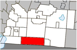
 Location within Brome-Missisquoi RCM. | |
| Coordinates: 45°03′N 72°50′W / 45.050°N 72.833°W[1] | |
| Country | Canada |
| Province | Quebec |
| Region | Estrie |
| RCM | Brome-Missisquoi |
| Constituted | September 28, 1985 |
| Government | |
| • Mayor | Lucie Dagenais |
| • Federal riding | Brome—Missisquoi |
| • Prov. riding | Brome-Missisquoi |
| Area | |
| • Total | 124.60 km2 (48.11 sq mi) |
| • Land | 123.31 km2 (47.61 sq mi) |
| Population (2021)[3] | |
| • Total | 1,123 |
| • Density | 9.1/km2 (24/sq mi) |
| • Pop 2016-2021 | |
| • Dwellings | 622 |
| Time zone | UTC−5 (EST) |
| • Summer (DST) | UTC−4 (EDT) |
| Postal code(s) | |
| Area code(s) | 450 and 579 |
| Highways | |
| Website | https://frelighsburg.ca/ |
Frelighsburg is a municipality in the Estrie region of southern Quebec, Canada, on the border with Vermont. It is at the foot of Mount Pinnacle, part of the Appalachian Mountains.
Administratively, it is within the Brome-Missisquoi Regional County Municipality, in the Estrie. Its population, as of the Canada 2021 Census, was 1,123.
