| Fresno River | |
|---|---|
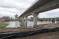
 Fresno River Viaduct, February 2017 | |
 | |
| Location | |
| Country | United States |
| State | California |
| Physical characteristics | |
| Source | Confluence of Lewis Fork Creek, Nelder Creek, and China Creek (Raymond Mountain) |
| • location | Oakhurst, Madera County |
| • coordinates | 37°21′43″N 119°37′58″W / 37.36194°N 119.63278°W[3] |
| • elevation | 2,510 ft (770 m) |
| Mouth | San Joaquin River |
• location | Near Dos Palos, Madera County |
• coordinates | 37°04′32″N 120°33′39″W / 37.07556°N 120.56083°W[3] |
• elevation | 108 ft (33 m) |
| Length | 83 mi (134 km) |
| Discharge | |
| • location | below Hidden Dam[1] |
| • average | 110 cu ft/s (3.1 m3/s)[2] |
| • minimum | 0 cu ft/s (0 m3/s) |
| • maximum | 17,500 cu ft/s (500 m3/s) |
| Basin features | |
| Tributaries | |
| • left | Nelder Creek, Coarse Gold Creek |
| • right | Lewis Fork Fresno River, Peterson Creek |
The Fresno River (Spanish for "ash tree") is a river in Central California and a major tributary of the San Joaquin River. It runs approximately 83 miles (134 km) from the Sierra Nevada Range to the San Joaquin River if measured from the source of Rainier Creek, near Raymond Mountain in Yosemite National Park. Although called the 'Fresno' River, it is one of the largest and longest river systems in Madera County.
- ^ "USGS Gage #11258000 on the Fresno River below Hidden Dam, CA". National Water Information System. U.S. Geological Survey. 1941–1990. Retrieved 2013-08-03.
- ^ "USGS Gage #11258000 on the Fresno River below Hidden Dam, CA". National Water Information System. U.S. Geological Survey. 1941–1990. Retrieved 2013-08-03.
- ^ a b "Fresno River". Geographic Names Information System. United States Geological Survey, United States Department of the Interior. 1981-01-19. Retrieved 2013-08-03.