| Fritwell | |
|---|---|
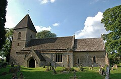
 St Olave's parish church | |
Location within Oxfordshire | |
| Population | 736 (2011 Census) |
| OS grid reference | SP5229 |
| Civil parish |
|
| District | |
| Shire county | |
| Region | |
| Country | England |
| Sovereign state | United Kingdom |
| Post town | Bicester |
| Postcode district | OX27 |
| Dialling code | 01869 |
| Police | Thames Valley |
| Fire | Oxfordshire |
| Ambulance | South Central |
| UK Parliament | |
| Website | Fritwell Parish Council |
Fritwell is a village and civil parish about 5+1⁄2 miles (9 km) northwest of Bicester in Oxfordshire. The 2011 Census recorded the parish's population as 736.[1]
The parish's southern boundary is a stream that flows eastwards through Fewcott and past the villages of Fringford and Godington before entering Buckinghamshire where it becomes part of Padbury Brook, a tributary of the Great Ouse. The northeastern boundary of Fritwell parish is the main road between Bicester and Banbury. On other sides the parish is bounded by field boundaries.
The Portway, a road that predates the Roman conquest of Britain, runs north–south parallel with the River Cherwell and passes through the western part of the parish. The village's toponym is derived from Fyrht-wielle or Fyrht-welle, which is Old English for a wishing well.[2]
- ^ "Area: Fritwell (Parish): Key Figures for 2011 Census: Key Statistics". Neighbourhood Statistics. Office for National Statistics. Retrieved 25 August 2015.
- ^ Lobel 1959, pp. 134–146
