| Frostenden | |
|---|---|
 Frostenden All Saints | |
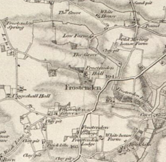
 19th Century Map of Frostenden | |
Location within Suffolk | |
| Population | 167 (2011 Census) |
| Civil parish |
|
| District | |
| Shire county |
|
| Region | |
| Country | England |
| Sovereign state | United Kingdom |
| Post town | BECCLES |
| Postcode district | NR34 |
| Dialling code | 01502 |
| Police | Suffolk |
| Fire | Suffolk |
| Ambulance | East of England |
Frostenden is a village and civil parish in the East Suffolk district of the English county of Suffolk. It is around 8 miles (13 km) south-west of Lowestoft and 3.5 miles (5.6 km) north-west of Southwold and lies on the A12 road between Wrentham and Wangford. Neighbouring parishes include Wrentham, Sotterley, Uggeshall, Wangford with Henham, Reydon and South Cove.[1]
At the 2011 United Kingdom census the population of the parish was 167.[1] The parish council operates jointly with the neighbouring parishes of South Cove and Uggeshall.[2] The parish church, All Saints, is one of around 40 round-tower churches in Suffolk.[a]
- ^ a b Village profile: Frostenden, East Suffolk District Council, October 2019. Retrieved 28 March 2023.
- ^ Frostenden, Uggeshall & South Cove, Healthy Suffolk. Retrieved 25 March 2023.
- ^ Round Tower Churches Map, The Temple Trail. Retrieved 9 March 2021.
- ^ Suffolk Churches, Weald and Downland Churches. Retrieved 9 March 2021.
- ^ Norfolk Round Tower Churches, Great English Churches. Retrieved 9 March 2021.
- ^ a b Hart S (2019) Round Tower Churches, Building Conservation, Cathedral Communications. Retrieved 9 March 2021.
- ^ a b Knott S Suffolk churches with round towers, Suffolk Churches. Retrieved 9 March 2021.
- ^ a b Welcome to the Round Tower Churches Society, The Round Tower Churches Society. Retrieved 9 March 2021.
Cite error: There are <ref group=lower-alpha> tags or {{efn}} templates on this page, but the references will not show without a {{reflist|group=lower-alpha}} template or {{notelist}} template (see the help page).
