Fulton County | |
|---|---|
 Fulton County Courthouse in Hickman | |
 Location within the U.S. state of Kentucky | |
 Kentucky's location within the U.S. | |
| Coordinates: 36°33′N 89°11′W / 36.55°N 89.19°W | |
| Country | |
| State | |
| Founded | 1845 |
| Named for | Robert Fulton |
| Seat | Hickman |
| Largest city | Hickman |
| Area | |
• Total | 231 sq mi (600 km2) |
| • Land | 206 sq mi (530 km2) |
| • Water | 25 sq mi (60 km2) 11% |
| Population (2020) | |
• Total | 6,515 |
• Estimate (2023) | 6,338 |
| • Density | 28/sq mi (11/km2) |
| Time zone | UTC−6 (Central) |
| • Summer (DST) | UTC−5 (CDT) |
| Congressional district | 1st |
| Website | www |
Fulton County is the westernmost county in the U.S. state of Kentucky, with the Mississippi River forming its western boundary. As of the 2020 census, the population was 6,515.[1] Its county seat is Hickman and its largest city is Fulton.[2] The county was formed in 1845 from Hickman County, Kentucky and named for Robert Fulton, the inventor of the steamboat.[3][4]
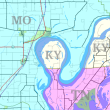
Allied with Tennessee by trade and culture, white Fulton County residents were largely pro-Confederate during the American Civil War. Forces from both armies passed through the county during different periods of the conflict.[5] Because of imprecise early surveying of Kentucky's southern border, Fulton County is divided into two non-contiguous parts. An exclave on the peninsula in the Kentucky Bend of the Mississippi River can be reached only by road through Tennessee.

- ^ "Census - Geography Profile: Fulton County, Kentucky". United States Census Bureau. Retrieved December 30, 2022.
- ^ "Find a County". National Association of Counties. Archived from the original on May 31, 2011. Retrieved June 7, 2011.
- ^ The Register of the Kentucky State Historical Society, Volume 1. Kentucky State Historical Society. 1903. pp. 35.
- ^ Hogan, Roseann Reinemuth (1992). Kentucky Ancestry: A Guide to Genealogical and Historical Research. Ancestry Publishing. p. 235. ISBN 9780916489496. Retrieved July 26, 2013.
- ^ "Fulton County, Kentucky Genealogy, Facts, Records & Links". Genealogyinc.com. Retrieved April 16, 2013.