This article needs additional citations for verification. (October 2012) |

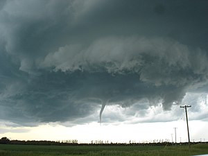
A funnel cloud is a funnel-shaped cloud of condensed water droplets, associated with a rotating column of wind and extending from the base of a cloud (usually a cumulonimbus or towering cumulus cloud) but not reaching the ground or a water surface.[1] A funnel cloud is usually visible as a cone-shaped or needle like protuberance from the main cloud base. Funnel clouds form most frequently in association with supercell thunderstorms, and are often, but not always, a visual precursor to tornadoes. Funnel clouds are visual phenomena, but these are not the vortex of wind itself.[2]
- ^ Glickman, Todd S. (2000). Glossary of Meteorology (2nd ed.). Boston: American Meteorological Society. ISBN 978-1878220349.
- ^ "Funnel cloud". National Weather Service Glossary. NOAA National Weather Service. Retrieved 2019-12-17.