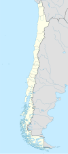
(Futrono)
Futronhue | |
|---|---|
| Coordinates (city): 40°08′S 72°24′W / 40.133°S 72.400°W | |
| Country | Chile |
| Regions of Chile | Los Ríos |
| Province | Ranco |
| Founded as | Futrono |
| Founded | 12 June 1941 |
| Government | |
| • Type | Municipality |
| • Alcalde | Jorge Guillermo Tatter Oñate (UDI) |
| Area | |
• Total | 2,120.6 km2 (818.8 sq mi) |
| Elevation | 67 m (220 ft) |
| Population (2012 Census)[3] | |
• Total | 13,736 |
| • Density | 6.5/km2 (17/sq mi) |
| • Urban | 8,399 |
| • Rural | 6,582 |
| Sex | |
| • Men | 7,647 |
| • Women | 7,334 |
| Time zone | UTC−4 (CLT) |
| • Summer (DST) | UTC−3 (CLST) |
| Area code | 56 + 63 |
| Website | www |
Futrono (from the Mapudungun: Futronhue, meaning "place of smoke") is a city and commune in southern Chile administered by the Municipality of Futrono. It is located in Ranco Province in Los Ríos Region, on the northwest shore of Ranco Lake.
- ^ "Asociación Chilena de Municipalidades" (in Spanish). Archived from the original on 5 May 2010. Retrieved 27 January 2011.
- ^ "Municipality of Futrono" (in Spanish). Archived from the original on 5 May 2010. Retrieved 27 January 2011.
- ^ a b c "National Statistics Institute" (in Spanish). Retrieved 13 December 2010.


