This article needs additional citations for verification. (September 2021) |
Koktokay County
Fuyun | |
|---|---|
 | |
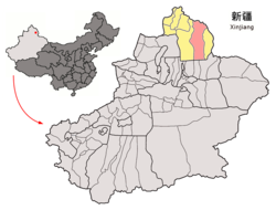
 Location of Fuyun County (red) in Altay Prefecture (yellow) and Xinjiang | |
| Coordinates: 47°13′N 89°39′E / 47.217°N 89.650°E | |
| Country | China |
| Autonomous region | Xinjiang |
| Prefecture | Altay |
| Township-level divisions | 3 towns 6 townships 3 ethnic townships |
| County seat | Ku Ertix |
| Area | |
• Total | 32,237 km2 (12,447 sq mi) |
| Dimensions | |
| • Length | 413 km (257 mi) |
| • Width | 180 km (110 mi) |
| Highest elevation | 3,863 m (12,674 ft) |
| Lowest elevation | 430 m (1,410 ft) |
| Population (2020)[1] | |
• Total | 99,748 |
| • Density | 3.1/km2 (8.0/sq mi) |
| Demographics | |
| • Major ethnic groups |
|
| Time zone | UTC+8 (China Standard[a]) |
| Postal code | 836100 |
| Website | www |
| Fuyun County | |||||||||||
|---|---|---|---|---|---|---|---|---|---|---|---|
| Chinese name | |||||||||||
| Simplified Chinese | 富蕴县 | ||||||||||
| Traditional Chinese | 富蘊縣 | ||||||||||
| |||||||||||
| Alternative Chinese name | |||||||||||
| Simplified Chinese | 可可托海县 | ||||||||||
| Traditional Chinese | 可可託海縣 | ||||||||||
| |||||||||||
| Mongolian name | |||||||||||
| Mongolian Cyrillic | Хөхтохой шянь | ||||||||||
| Mongolian script | ᠬᠥᠬᠡᠲᠣᠬᠣᠢ ᠰᠢᠶᠠᠨ | ||||||||||
| |||||||||||
| Uyghur name | |||||||||||
| Uyghur | كۆكتوقاي ناھىيىسى | ||||||||||
| |||||||||||
| Kazakh name | |||||||||||
| Kazakh | كوكتوعاي اۋدانى Көктоғай ауданы Köktoğai audany | ||||||||||
Koktokay county (Chinese: 富蕴县), also known as Fuyun County (Uyghur: كۆكتوقاي ناھىيىسى; Chinese: 可可托海县; Kazakh: كوكتوعاي اۋدانى), is a county of Altay Prefecture, in the Xinjiang Uyghur Autonomous Region of China. It has an area of 32,237 km2 with a population of 80,000. The seat of Fuyun County is in Ku Ertix Town. The Koktokay National Geopark is in Koktokay Town. The postal code of Fuyun County is 836100. The county is served by Fuyun Keketuohai Airport.
Cite error: There are <ref group=lower-alpha> tags or {{efn}} templates on this page, but the references will not show without a {{reflist|group=lower-alpha}} template or {{notelist}} template (see the help page).


