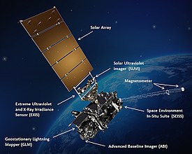
 Artist's impression of GOES-16 in orbit around Earth with major instruments labeled | |||||||||||||||
| Names | GOES-R (before 29 November 2016) | ||||||||||||||
|---|---|---|---|---|---|---|---|---|---|---|---|---|---|---|---|
| Mission type | Geostationary weather satellite | ||||||||||||||
| Operator | NASA/NOAA | ||||||||||||||
| COSPAR ID | 2016-071A | ||||||||||||||
| SATCAT no. | 41866 | ||||||||||||||
| Website | www | ||||||||||||||
| Mission duration | Planned: 15 years Elapsed: 8 years, 3 days | ||||||||||||||
| Spacecraft properties | |||||||||||||||
| Bus | A2100A | ||||||||||||||
| Manufacturer | Lockheed Martin | ||||||||||||||
| Launch mass | 5,192 kg (11,446 lb) | ||||||||||||||
| Dry mass | 2,857 kg (6,299 lb) | ||||||||||||||
| Dimensions | 6.1 × 5.6 × 3.9 m (20 × 18 × 13 ft) | ||||||||||||||
| Power | 4 kW | ||||||||||||||
| Start of mission | |||||||||||||||
| Launch date | 19 November 2016, 23:42 UTC | ||||||||||||||
| Rocket | Atlas V 541 (AV-069) | ||||||||||||||
| Launch site | Cape Canaveral SLC-41 | ||||||||||||||
| Contractor | United Launch Alliance | ||||||||||||||
| Entered service | 18 December 2017 | ||||||||||||||
| Orbital parameters | |||||||||||||||
| Reference system | Geocentric | ||||||||||||||
| Regime | Geostationary | ||||||||||||||
| Longitude | 75.2° West | ||||||||||||||
| Slot | GOES East (after 18 December 2017) | ||||||||||||||
| Semi-major axis | 42,164.8 km (26,200.0 mi) | ||||||||||||||
| Eccentricity | 0.0001538 | ||||||||||||||
| Perigee altitude | 35,780.2 km (22,232.8 mi) | ||||||||||||||
| Apogee altitude | 35,793.1 km (22,240.8 mi) | ||||||||||||||
| Inclination | 0.0363° | ||||||||||||||
| Period | 1,436.1 minutes | ||||||||||||||
| Epoch | 1 March 2018, 18:22:45[1] | ||||||||||||||
| |||||||||||||||
 GOES-R mission insignia | |||||||||||||||
GOES-16, formerly known as GOES-R before reaching geostationary orbit, is the first of the GOES-R series of Geostationary Operational Environmental Satellites (GOES) operated by NASA and the National Oceanic and Atmospheric Administration (NOAA). GOES-16 serves as the operational geostationary weather satellite in the GOES East position at 75.2°W, providing a view centered on the Americas. GOES-16 provides high spatial and temporal resolution imagery of the Earth through 16 spectral bands at visible and infrared wavelengths using its Advanced Baseline Imager (ABI). GOES-16's Geostationary Lightning Mapper (GLM) is the first operational lightning mapper flown in geostationary orbit. The spacecraft also includes four other scientific instruments for monitoring space weather and the Sun.
GOES-16's design and instrumentation began in 1999 and was intended to fill key NOAA satellite requirements published that year. Following nearly a decade of instrument planning, spacecraft fabrication was contracted to Lockheed Martin Space Systems in 2008; construction of GOES-16 began in 2012 and lasted until 2014 when the satellite entered the testing phase. After several launch delays, GOES-16 launched from Cape Canaveral on 19 November 2016 aboard a United Launch Alliance (ULA) Atlas V. The spacecraft reached an initial geostationary orbit several days later, beginning a yearlong non-operational checkout and validation phase. In November 2017, GOES-16 began a drift to its operational GOES East position, and was declared as fully operational on 18 December 2017. The satellite is expected to have an operational lifespan of ten years, with five additional years as a backup for successive GOES spacecraft.
- ^ "GOES-R - Orbit". Heavens-Above. 1 March 2018. Retrieved 4 March 2018.