| Gabalfa | |
|---|---|
 St Marks Church, Gabalfa | |
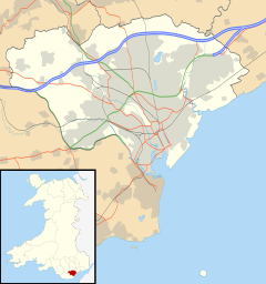
Location within Cardiff | |
| Population | 8,790 (2011)[1] |
| Principal area | |
| Preserved county | |
| Country | Wales |
| Sovereign state | United Kingdom |
| Post town | CARDIFF |
| Postcode district | CF14 |
| Dialling code | +44-29 |
| Police | South Wales |
| Fire | South Wales |
| Ambulance | Welsh |
| UK Parliament | |
| Senedd Cymru – Welsh Parliament | |
Gabalfa (English: /ɡəˈbælvə/, Welsh pronunciation: [ɡaˈbalva]) is a district and community in the north of the city of Cardiff, capital of Wales. It is characterised by a four-lane flyover road at the Gabalfa Interchange, where the A48 road meets the A470 road (North Road) which leads from Cardiff to northern Wales, and the A469 road (Caerphilly Road).
The name is derived from the Welsh Ceubalfa, literally translated as 'place of the boat'. It was formerly the site of a ferry crossing across the River Taff, upon which a school is now built.[2] The area was first heavily developed in the 1880s, with most of the characteristic terraced housing originating from the next 30 years of construction.[3]
The area around St. Joseph's Church near to Companies House is known as 'the Colonies' due to a number of streets named after former British colonies, including Australia Road and Newfoundland Road.
- ^ "Ward population 2011". Retrieved 8 April 2015.
- ^ "Gabalfa". Streets of Cardiff. BBC Wales. Retrieved 16 January 2008.
- ^ "Gabalfa". National Museum Cardiff. Retrieved 22 August 2019.


