Gallipolis, Ohio | |
|---|---|
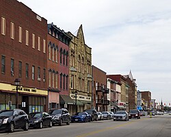
 Downtown Gallipolis | |
| Nickname: City of the Gauls[1] | |
 Location of Gallipolis, Ohio | |
 Location of Gallipolis in Gallia County | |
| Coordinates: 38°49′07″N 82°11′36″W / 38.81861°N 82.19333°W | |
| Country | United States |
| State | Ohio |
| County | Gallia |
| Township | Gallipolis |
| Founded | October 17, 1790[2] |
| Area | |
| • Total | 3.83 sq mi (9.91 km2) |
| • Land | 3.60 sq mi (9.32 km2) |
| • Water | 0.23 sq mi (0.59 km2) |
| Elevation | 571 ft (174 m) |
| Population (2020) | |
| • Total | 3,313 |
| • Estimate (2023)[5] | 3,284 |
| • Density | 921.05/sq mi (355.57/km2) |
| Time zone | UTC-5 (Eastern (EST)) |
| • Summer (DST) | UTC-4 (EDT) |
| ZIP code | 45631 |
| Area code | 740 |
| FIPS code | 39-29204[6] |
| GNIS feature ID | 2398939[4] |
| Website | Village of Gallipolis website |
Gallipolis (/ˌɡæləpəˈliːs/ GAL-ə-pə-LEESS[7]) is a chartered village in and the county seat of Gallia County, Ohio, United States.[8] The municipality is located in Southeast Ohio along the Ohio River about 55 miles (89 km) southeast of Chillicothe and 44 miles (71 km) northwest of Charleston, West Virginia. The population was 3,313 at the 2020 census. Gallipolis is the second-largest community in the rural Point Pleasant micropolitan area, which includes all of Gallia County, Ohio, and Mason County, West Virginia.
- ^ "The History of Gallipolis, Ohio". Archived from the original on September 16, 2008. Retrieved September 4, 2008.
- ^ "The History of Gallipolis, Ohio". Archived from the original on September 16, 2008. Retrieved July 18, 2018.
- ^ "ArcGIS REST Services Directory". United States Census Bureau. Retrieved September 20, 2022.
- ^ a b U.S. Geological Survey Geographic Names Information System: Gallipolis, Ohio
- ^ "Annual Estimates of the Resident Population for Incorporated Places in Ohio: April 1, 2020 to July 1, 2023". United States Census Bureau. Retrieved June 27, 2024.
- ^ "U.S. Census website". United States Census Bureau. Retrieved January 31, 2008.
- ^ "E.W. Scripps School of Journalism Ohio Pronunciation Guide | Ohio University". www.ohio.edu. Ohio University. 2016. Retrieved January 2, 2024.
- ^ "Find a County". National Association of Counties. Archived from the original on May 31, 2011. Retrieved June 7, 2011.