| Gamtoos River Gamtoosrivier | |
|---|---|
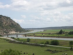
 Gamtoos River near its mouth into the Indian Ocean between Port Elizabeth and Jeffreys Bay, with the R102 bridge in the foreground and the N2 bridge in the background. | |
| Etymology | Probably derived from a Khoikhoi clan whose name was given by early Dutch settlers as "Gamtousch" |
| Location | |
| Country | |
| Province | Eastern Cape |
| Physical characteristics | |
| Source | _ |
| Source confluence | Kouga River / Groot River |
| • coordinates | 33°44′45″S 24°36′55″E / 33.74583°S 24.61528°E |
| • elevation | 90 m (300 ft) |
| Mouth | Indian Ocean |
• location | St. Francis Bay, Eastern Cape, South Africa |
• coordinates | 33°58′8.75″S 25°1′58.08″E / 33.9690972°S 25.0328000°E |
• elevation | 0 m (0 ft) |
| Length | 645 km (401 mi) |
| Basin size | 34,635 km2 (13,373 sq mi) |

Gamtoos River or Gamptoos River is a river in the Eastern Cape Province, South Africa. It is formed by the confluence of the Kouga River and the Groot River and is approximately 645 kilometres (401 mi) long[citation needed] with a catchment area of 34,635 square kilometres (13,373 sq mi).[1]
- ^ "Fish to Tsitsikamma WMA 15". Archived from the original on 2017-06-30. Retrieved 2012-03-28.
