Gandhidham | |
|---|---|
City | |
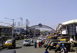
 Dadi Nirmala Gajwani Market Gate | |
| Nickname: Sardar Ganj | |
| Coordinates: 23°05′N 70°08′E / 23.08°N 70.13°E | |
| Country | |
| State | Gujarat |
| District | Kutch |
| Founded by | Bhai Pratap |
| Government | |
| • Type | Municipal Corporation |
| • Body | Gandhidham Municipal Corporation |
| Area | |
• Total | 63.49 km2 (24.51 sq mi) |
| Elevation | 27 m (89 ft) |
| Population (2011) | |
• Total | 248,705 |
| • Rank | 181 |
| • Density | 3,900/km2 (10,000/sq mi) |
| Languages = Official | |
| Time zone | UTC+5:30 |
| PIN | 370201, 370203, 370205, 370230, 370240 |
| Telephone code | 02836 |
| Vehicle registration | GJ-39 |
| Sex ratio | 0.879 ♂/♀ |
| Distance from Bhuj | 60 kilometres (37 mi) |
| Distance from Gandhinagar | 365 kilometres (227 mi) |
| Website | https://www.gandhidhamnagarpalika.org/ |
Gandhidham, initially known as Sardarganj, located in the eastern part of Kutch district, in the state of Gujarat. It is the largest and most populous city in (Kachchh) Kutch District, Gujarat, India.[1] It was created in the early 1950s for the resettlement of Sindhi Hindu refugees from Sindh, Pakistan, in the aftermath of the partition of India.[2] The city was named after M K Gandhi. An economic capital of Kutch, Gandhidham is a growing area for families and retirees. According to the 2011 Census, Gandhidham is Gujarat's 8th[3][4] most populous city. It is a popular destination for conventions, business, and meetings.
- ^ Postal Code Information, India TV. "Gandhidham Pin Code, Postal Code (Zip Code) of Gandhidham, Kachchh, Gujarat, India". www.indiatvnews.com.
- ^ "Gandhidham – City – Gujarat Updates". 11 January 2017. Retrieved 22 October 2023.
- ^ List of cities in Gujarat by population
- ^ "Gujarat Population Census data 2011". www.census2011.co.in.
