| Gannett Peak | |
|---|---|
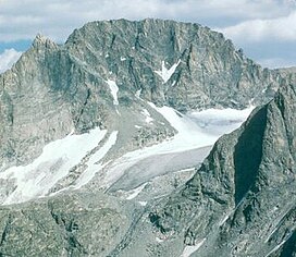
 West face of Gannett Peak | |
| Highest point | |
| Elevation | 13,810 ft (4,210 m)[1] |
| Prominence | 7,076 ft (2,157 m) |
| Parent peak | Longs Peak[2] |
| Isolation | 290.36 mi (467.29 km)[3] |
| Listing | |
| Coordinates | 43°11′03″N 109°39′15″W / 43.184202022°N 109.654233614°W[3] |
| Geography | |
| Location | Fremont and Sublette Counties, Wyoming, United States |
| Parent range | Wind River Range |
| Topo map | USGS Gannett Peak |
| Climbing | |
| First ascent | 1922 by A. Tate and F. Stahlnaker |
| Easiest route | rock/ice climb |
Gannett Peak[4] is the highest mountain peak in the U.S. state of Wyoming at 13,810 feet (4,210 m). It lies in the Wind River Range within the Bridger Wilderness of the Bridger-Teton National Forest. Straddling the Continental Divide along the boundary between Fremont and Sublette counties, it has the second greatest topographic prominence in the state (7076') after Cloud Peak (7077'), and is the highest ground for 290.36 miles (467.29 kilometers) in any direction.
- ^ "Gannett Peak NAVD88 Elevation".
- ^ "Gannett Peak". ListsOfJohn.com. Retrieved 2008-12-05.
- ^ a b "Gannett Peak Isolation".
- ^ U.S. Geological Survey Geographic Names Information System: Gannett Peak
