| Gardner Lake | |
|---|---|
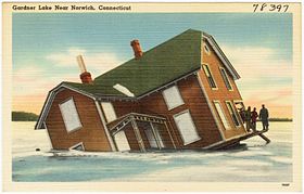
 Postcard illustration of Gardner Lake's iconic sinking house | |
| Location | Salem, Montville and Bozrah, Connecticut. |
| Coordinates | 41°30′44″N 72°13′36″W / 41.51222°N 72.22667°W [1] |
| Lake type | Natural lake |
| Primary inflows | Whittle Brook, Sucker Brook |
| Primary outflows | Gardner Brook |
| Basin countries | United States |
| Max. length | 1.68 miles (2.70 km) |
| Max. width | 3,776 feet (1,151 m) |
| Surface area | 529 acres (214 ha) [2] |
| Average depth | 18 feet (5.5 m) |
| Max. depth | 36 feet (11 m) [2] |
| Residence time | 320 days[3] |
| Surface elevation | 381 feet (116 m) [1] |
| Islands | 1 (Minnie Island) |
Gardner Lake is a natural lake lying at the junction of the towns of Salem, Montville and Bozrah in Connecticut, USA. Named after the Gardner family who owned a large portion of the surrounding land, the 529-acre (214 ha) lake has been expanded in size with the construction of a 168-foot (51 m) earthen dam. The dam raises the water level up 4 feet (1.2 m) to an average depth of 14 feet (4.3 m).[4] The area surrounding Gardner Lake has dozens of private homes, four campgrounds and a marina.[5] Three state parks are located around the lake: Minnie Island State Park, Hopemead State Park and Gardner Lake State Park.
- ^ a b "Gardner Lake". Geographic Names Information System. United States Geological Survey, United States Department of the Interior.
- ^ a b "Gardner Lake" (PDF). Connecticut Department of Energy and Environmental Protection. September 2011. Retrieved 8 December 2018.
- ^ "Water-Quality Characteristics of Selected Public Recreational Lakes and Ponds in Connecticut" (PDF). U.S. Geological Survey. 1995. Retrieved 8 December 2018.
- ^ "Gardner Lake State Park". State Parks and Forests. Connecticut Department of Energy and Environmental Protection. Retrieved 6 February 2013.
- ^ Cite error: The named reference
day12was invoked but never defined (see the help page).
