30°30′N 78°30′E / 30.5°N 78.5°E
This article needs additional citations for verification. (July 2013) |
Garhwal
Kedarkhand | |
|---|---|
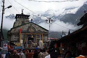
Clockwise from top: Kedarnath Mandir, Bedni Bugyal, Valley of Flowers, Mt. Nanda Devi, Confluence of Bhagirathi and Alaknanda at Devaprayag, Mussoorie covered with snow, Lakshman Jhula on Ganges at Rishikesh, Auli Ski Resort | |
 Location in India | |
| Country | |
| State | Uttarakhand |
| Established | 1969[1] |
| Headquarter | Pauri |
| Largest City | Dehradun |
| Districts | |
| Government | |
| • Commissioner | Vinay Shankar Pandey[2] |
| Area | |
• Total | 32,887 km2 (12,698 sq mi) |
| Population (2011 census) | |
• Total | 5,857,294 |
| • Density | 180/km2 (460/sq mi) |
| Demonym | Garhwali |
| Languages | |
| Time zone | UTC+5:30 (IST) |
| Highest peak of Garhwal division | Nanda Devi (7,816 m (25643 ft) |
| Website | https://garhwal.uk.gov.in/ |
Garhwal (IPA: /ɡəɽʋːɔɭ/) is one of the two administrative divisions of the Indian state of Uttarakhand.[6] Lying in the Himalayas, it is bounded on the north by Tibet, on the east by Kumaon, on the south by Uttar Pradesh state, and on the northwest by Himachal Pradesh state. It includes the districts of Chamoli, Dehradun, Haridwar, Pauri Garhwal, Rudraprayag, Tehri Garhwal, and Uttarkashi. The people of Garhwal are known as Garhwali and speak the Garhwali language. The administrative center for Garhwal division is the town of Pauri. The Divisional Commissioner is the administrative head of the Division, and is a senior Indian Administrative Service officer. As the administrative head of the division, the Commissioner is overall incharge of the 7 districts in the Garhwal region of Uttarakhand, and is aided in his duties by an additional commissioner and the district magistrates. Sushil Kumar is the divisional commissioner of the Garhwal Division since December 2021.[7][8]
- ^ "History | District Pauri Garhwal, Government of Uttarakhand | India".
- ^ "Divisional Commissioner details: Office of Commissioner Garhwal, Pauri". garhwal.uk.gov.in. Retrieved 14 September 2022.
- ^ "Report of the Commissioner for linguistic minorities: 50th report (July 2012 to June 2013)" (PDF). Commissioner for Linguistic Minorities, Ministry of Minority Affairs, Government of India. Archived from the original (PDF) on 8 July 2016. Retrieved 4 December 2016.
- ^ Trivedi, Anupam (19 January 2010). "Sanskrit is second official language in Uttarakhand". Hindustan Times. Archived from the original on 1 February 2012. Retrieved 30 August 2017.
- ^ "Sanskrit second official language of Uttarakhand". The Hindu. 21 January 2010. Archived from the original on 3 March 2018. Retrieved 30 August 2017.
- ^ "Home: Office of Commissioner Garhwal, Pauri". garhwal.uk.gov.in. Retrieved 5 September 2021.
- ^ "Divisional Commissioner details: Office of Commissioner Garhwal, Pauri". garhwal.uk.gov.in. Retrieved 26 July 2022.
- ^ "कमिश्नर गढ़वाल सुशील कुमार ने संभाला कार्यभार". Hindustan (in Hindi). 2 December 2021. Retrieved 26 July 2022.


