| Gasherbrum IV | |
|---|---|
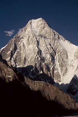
 Gasherbrum IV's West Face, seen from Baltoro Glacier | |
| Highest point | |
| Elevation | 7,925 m (26,001 ft)[1] Ranked 17th |
| Prominence | 718 m (2,356 ft)[2] |
| Coordinates | 35°45′30″N 76°37′0″E / 35.75833°N 76.61667°E[2] |
| Geography | |
| Location | Gilgit-Baltistan region, Pakistan |
| Parent range | Baltoro Muztagh, Karakoram |
| Climbing | |
| First ascent | August 6, 1958 by Walter Bonatti and Carlo Mauri |
| Easiest route | Northwest Ridge |
| Gasherbrum IV | |||
|---|---|---|---|
| Traditional Chinese | 加舒爾布魯木IV峰 | ||
| |||
Gasherbrum IV (Urdu: گاشر برم ۔ ۴; simplified Chinese: 加舒尔布鲁木IV峰; traditional Chinese: 加舒爾布魯木IV峰; pinyin: Jiāshūěrbùlǔmù IV Fēng), surveyed as K3, is the 17th highest mountain on Earth and the 6th highest in Pakistan, as well as the highest independent mountain under eight thousand meters in Pakistan.
One of the peaks in the Gasherbrum massif, its immense West Face looms over the glacial junction of Concordia. The Name "Gasherbrum" is often claimed to mean "Shining Wall", presumably a reference to this face's tendency to reflect the rays of the setting sun, but in fact it comes from "rgasha" (beautiful) and "brum" (mountain) in Balti, hence it actually means "beautiful mountain."[3]
Despite its lower height relative to the surrounding eight-thousanders, Gasherbrum IV is a venerated challenge among mountaineers.[4]
- ^ "Gasherbrum IV". SummitPost.org. Retrieved 5 June 2013.
- ^ a b "Gasherbrum IV". Peakbagger.com. Retrieved 5 June 2013.
- ^ H. Adams Carter, "Balti Place Names in the Karakoram", American Alpine Journal 49 (1975), p. 53.
- ^ Kurtyka, Wojciech (1986). "The Shining Wall of Gasherbrum IV". American Alpine Journal. American Alpine Club. Retrieved 25 February 2023.

