Gaviota, California | |
|---|---|
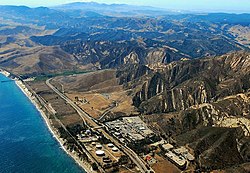
 Gaviota Coast, including the oil installation and much of Gaviota State Park, 2009 | |
| Coordinates: 34°28′18″N 120°12′50″W / 34.47167°N 120.21389°W | |
| Country | United States |
| State | California |
| County | Santa Barbara |
| Elevation | 102 ft (31 m) |
| Time zone | UTC-8 (Pacific (PST)) |
| • Summer (DST) | UTC-7 (PDT) |
| Area code(s) | 805 & 820 |
| GNIS feature ID | 271285[1] |

Gaviota (Spanish for "Seagull") is an unincorporated community in Santa Barbara County, California on the Gaviota Coast about 30 miles (48 km) west of Santa Barbara and 15 miles (24 km) south of Buellton.
Gaviota is south and east of Gaviota State Park. The road to Hollister Ranch, the large private land holding along the coast between Gaviota and Point Conception, connects with U.S. 101 just west of Gaviota, at the turnoff to Gaviota State Park.[2][3][4]
Industries in the area include organic farming, ranching, and woodworking. Free range cattle can be seen roaming and grazing throughout the area. Gaviota is also home to a marine mammal rehabilitation center named The Channel Islands Marine & Wildlife Institute (CIMWI.org) which opened in 2006 at the historic Vista Del Mar School grounds.[5]
Gaviota was once the location of the Gaviota Marine Terminal, which is currently being decommissioned and abandoned, with intent to become public open space.[6] On the mountain side of the freeway is the Gaviota Oil Heating Facility, also known as the "Gaviota Gas Plant", built by Chevron Corp. and currently owned by Plains Exploration & Production Company (PXP); this facility is being reconfigured and partially abandoned. The former purpose of the facility was to heat and process the heavy crude oil produced offshore so that it could flow through the All American Pipeline to refineries in the Bakersfield area.[6]
- ^ "Yosemite Junction". Geographic Names Information System. United States Geological Survey, United States Department of the Interior.
- ^ Kettmann, Matt (December 14, 2010). "Baron Ranch Calling All Hikers". Santa Barbara Independent. Retrieved March 19, 2017.
- ^ Stewart, Ethan (February 14, 2013). "Illegal Pipes Removed". Santa Barbara Independent. Retrieved March 19, 2017.
- ^ Stewart, Ethan (November 6, 2006). "Gaviota Goes to County Supes". Santa Barbara Independent. Retrieved March 19, 2017.
- ^ Hayden, Tyler (July 11, 2011). "Hollisters Donate Last Piece of Land to Animal Rehab Center". Santa Barbara Independent.
- ^ a b "Gaviota/Arguello Abandonment project". Energy Division. County of Santa Barbara Planning and Development. Retrieved September 13, 2016.

