| Gayndah Queensland | |||||||||||||||
|---|---|---|---|---|---|---|---|---|---|---|---|---|---|---|---|
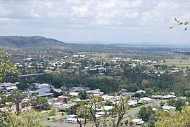
 Gayndah, seen from the town lookout | |||||||||||||||
| Coordinates | 25°37′28″S 151°36′29″E / 25.6244°S 151.6080°E | ||||||||||||||
| Population | 1,949 (2021 census)[1] | ||||||||||||||
| • Density | 28.620/km2 (74.12/sq mi) | ||||||||||||||
| Established | 1849 | ||||||||||||||
| Postcode(s) | 4625 | ||||||||||||||
| Elevation | 106 m (348 ft) | ||||||||||||||
| Area | 68.1 km2 (26.3 sq mi) | ||||||||||||||
| Time zone | AEST (UTC+10:00) | ||||||||||||||
| Location |
| ||||||||||||||
| LGA(s) | North Burnett Region | ||||||||||||||
| State electorate(s) | Callide | ||||||||||||||
| Federal division(s) | Flynn | ||||||||||||||
| |||||||||||||||
| |||||||||||||||
Gayndah (/ɡeɪndə/)[2] is a town and locality in the North Burnett Region, Queensland, Australia.[3][4] It is the administrative centre for the North Burnett Region. In the 2021 census, the locality of Gayndah had a population of 1,949 people.[1]
- ^ a b Cite error: The named reference
Census2021was invoked but never defined (see the help page). - ^ Macquarie Dictionary, Fourth Edition (2005). Melbourne, The Macquarie Library Pty Ltd. ISBN 1-876429-14-3
- ^ "Gayndah – town in North Burnett Region (entry 13515)". Queensland Place Names. Queensland Government. Retrieved 2 August 2019.
- ^ "Gayndah – locality in North Burnett Region (entry 45349)". Queensland Place Names. Queensland Government. Retrieved 2 August 2019.
