This article has multiple issues. Please help improve it or discuss these issues on the talk page. (Learn how and when to remove these messages)
|
General Tinio | |
|---|---|
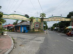
 Welcome Arch | |
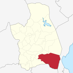
 Map of Nueva Ecija with General Tinio highlighted | |
Location within the Philippines | |
| Coordinates: 15°21′N 121°03′E / 15.35°N 121.05°E | |
| Country | Philippines |
| Region | Central Luzon |
| Province | Nueva Ecija |
| District | 4th district |
| Founded | 1921 |
| Named for | Manuel Tinio |
| Barangays | 13 (see Barangays) |
| Government | |
| • Type | Sangguniang Bayan |
| • Mayor | Engr. Isidro T. Pajarillaga |
| • Vice Mayor | Melvin S. Pascual |
| • Representative | Emerson D. Pascual |
| • Municipal Council | Members |
| • Electorate | 39,556 voters (2022) |
| Area | |
• Total | 245.29 km2 (94.71 sq mi) |
| Elevation | 56 m (184 ft) |
| Highest elevation | 113 m (371 ft) |
| Lowest elevation | 32 m (105 ft) |
| Population (2020 census)[3] | |
• Total | 55,925 |
| • Density | 230/km2 (590/sq mi) |
| • Households | 13,137 |
| Economy | |
| • Income class | 1st municipal income class |
| • Poverty incidence | 12.61 |
| • Revenue | ₱ 242.3 million (2020) |
| • Assets | ₱ 433.3 million (2020) |
| • Expenditure | ₱ 213.8 million (2020) |
| • Liabilities | ₱ 238 million (2020) |
| Service provider | |
| • Electricity | Nueva Ecija 2 Area 2 Electric Cooperative (NEECO 2 A2) |
| Time zone | UTC+8 (PST) |
| ZIP code | 3104 |
| PSGC | |
| IDD : area code | +63 (0)44 |
| Native languages | Southern Alta Tagalog Ilocano |
| Website | www |
General Tinio, formerly known as Papaya, is a first-class[5] municipality in the province of Nueva Ecija, Philippines with an area of 68,229.29 hectares, the second biggest in the province. It lies at the foot of the Sierra Madre Mountains and encompass parts of its mountain range and rugged foothills. General Tinio is bounded at the north by Sta. Rosa (25 km), Laur and Gabaldon municipalities. In East by Quezon (formerly Tayabas), in South by Gapan (20 km), Nueva Ecija and San Miguel, Bulacan and in West by Penaranda municipality (5.0 km).

Due to its river boundaries, streams, thick vegetation, rolling hills and mountains, the town served as a tactical rallying point (Tagalog: ilíhan or taguan) for various resistance movements throughout history—starting with the Katipunan during the Philippine Revolution, followed by Filipino insurgents during the American period, the Hukbalahap during the Japanese occupation, and later, communist rebels—making it a key refuge for patriots and insurgents across multiple eras of struggle. Renamed in 1957 to honor of General Manuel Tinio y Bundoc, the youngest general of the revolution, the town holds stories of heroism and resilience that remain largely untold and forgotten by many today. While its historical significance is quietly embedded in its landscapes and traditions, the present generation has yet to rediscover and appreciate its remarkable contributions to the country's fight for independence. General Tinio includes portions of the Sierra Madre mountain range and its rugged foothills while being bordered by the Peñaranda River at the south. It is traversed by several rivers and streams including Rio Chico River. The town's hilly terrain and dense wild vegetation made it a natural strategic refuge for insurgents resisting colonization during the Spanish, American, Japanese occupations; and other rebel groups. These physical barriers allowed freedom fighters to rest and regroup, contributing to the absence of major battles within the town.

The town has since developed into a thriving agricultural hub known for its rich cultural festivals - like the Kalamay Festival - and natural attractions like Minalungao National Park. The town's inspiring history, resilient leaders, and strong sense of community across its barangays continue to shape its legacy and drive its progress. The town is still locally referred to as Papaya but officially called the Municipality of General Tinio (Tagalog: Bayan ng Heneral Tinio, Ilocano: Ili ti Heneral Tinio). It posted an income of 260 M Php in 2020.[6] According to the 2020 census, it has a population of 55,925 people.[3]

To the northeast side is the Fort Magsaysay Army Reservation, wherein the national hero Ninoy Aquino and former Senator Jose Diokno were incarcerated during Martial Law in the 1970s. On the north are the towns of Gabaldon and Laur, named after Laureana Quijano, the wife of General Manuel Tinio.
The town is part of the great Sierra Madre Mountains to the East where the indigenous people of Agta or Dumagat live; and where patriots and rebels hid; further to the east and over the mountains is the beach town and the next tuna capital of the Philippines,[7] Dinggalan.
To the West are the historic towns of Sta. Rosa (25 km), Peñaranda (5.0 km) and the old city of Gapan where you will find the first minor basilica in Nueva Ecija, the National Shrine of La Virgen Divina Pastora, also known as the Three Kings Parish, or simply known as Gapan Church. To the south are the Peñaranda River that leads to the Minalungao National Park and; the town of Doña Remedios Trinidad, named after the former First Lady Imelda Marcos.
- ^ Municipality of General Tinio | (DILG)
- ^ "2015 Census of Population, Report No. 3 – Population, Land Area, and Population Density" (PDF). Philippine Statistics Authority. Quezon City, Philippines. August 2016. ISSN 0117-1453. Archived (PDF) from the original on May 25, 2021. Retrieved July 16, 2021.
- ^ a b Census of Population (2020). "Region III (Central Luzon)". Total Population by Province, City, Municipality and Barangay. Philippine Statistics Authority. Retrieved 8 July 2021.
- ^ "PSA Releases the 2021 City and Municipal Level Poverty Estimates". Philippine Statistics Authority. 2 April 2024. Retrieved 28 April 2024.
- ^ "Atin ang Pilipinas - Local Races - General Tinio". www.rappler.com. May 13, 2022. Retrieved September 27, 2024.
- ^ Republic of the Philippines, Commission on Audit. "2021 COA Executive Report for General Tinio" (PDF). Commission on Audit Executive Summary. Retrieved September 21, 2024.
- ^ Ochave, Revin Mikhael D. (August 3, 2020). "Dingalan town to be developed as next 'tuna capital'". Business World. Retrieved September 21, 2024.


