General Wm. J. Fox Airfield | |||||||||||
|---|---|---|---|---|---|---|---|---|---|---|---|
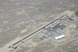
 Fox Field (February 2008) | |||||||||||
| Summary | |||||||||||
| Airport type | Public | ||||||||||
| Owner | County of Los Angeles | ||||||||||
| Serves | Lancaster, California | ||||||||||
| Elevation AMSL | 2,351 ft / 717 m | ||||||||||
| Coordinates | 34°44′28″N 118°13′07″W / 34.74111°N 118.21861°W | ||||||||||
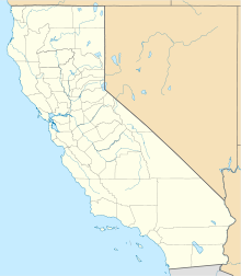
| Map | |||||||||||
 | |||||||||||
| Runways | |||||||||||
| |||||||||||
| Statistics (2021) | |||||||||||
| |||||||||||
General William J. Fox Airfield (IATA: WJF, ICAO: KWJF, FAA LID: WJF) is a county-owned, public airport in Los Angeles County, California,[1] five miles northwest of Lancaster, California, United States.[1] Locally known as Fox Field, the airport serves the Antelope Valley. The airport is named after Brigadier General William J. Fox, "a Marine war hero, a movie stunt man, the first Los Angeles County engineer and, for 20 years after his retirement, a cowboy."[2]
The National Plan of Integrated Airport Systems for 2011–2015 categorized it as a general aviation facility.[3] The airport has limited scheduled cargo operations. The U.S. Forest Service has a fixed wing airtanker and helicopter base on the airfield which becomes one of the main hubs in the region for aerial firefighting suppression efforts during fire season.
- ^ a b c FAA Airport Form 5010 for WJF PDF. Federal Aviation Administration. Effective July 11, 2024.
- ^ "William J. Fox, 95, a War Hero, Engineer, Stunt Man and Cowboy". obituary. New York Times. April 17, 1993. Retrieved March 19, 2021.
- ^ "2011–2015 NPIAS Report, Appendix A" (PDF). National Plan of Integrated Airport Systems. Federal Aviation Administration. October 4, 2010. Archived from the original (PDF, 2.03 MB) on 2012-09-27.
