| Genesee River | |
|---|---|
 Genesee River near Belmont | |
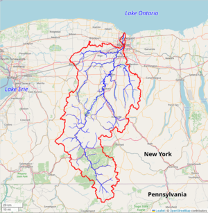
 Genesee River watershed (Interactive map) | |
| Native name | Čunehstí•yu• (Tuscarora)[1] |
| Location | |
| Country | United States |
| State | New York, Pennsylvania |
| Counties | (see Navbox, below) |
| City | Rochester, NY |
| Physical characteristics | |
| Source | |
| • location | Ulysses Township, Potter County, Pennsylvania |
| • coordinates | 41°53′33″N 77°43′54″W / 41.89250°N 77.73167°W[2] |
| • elevation | 2,275 ft (693 m)[3] |
| Mouth | Lake Ontario |
• location | Charlotte, Rochester, Monroe County, New York |
• coordinates | 43°15′30″N 77°36′08″W / 43.25833°N 77.60222°W[2] |
• elevation | 243 ft (74 m)[2] |
| Length | 157 mi (253 km) |
| Basin size | 2,500 sq mi (6,500 km2) |
| Discharge | |
| • location | Lake Ontario |
| Discharge | |
| • location | Portageville, NY |
The Genesee River (/ˌdʒɛnɪˈsiː/ JEN-iss-EE) is a tributary of Lake Ontario flowing northward through the Twin Tiers of Pennsylvania and New York in the United States. The river contains several waterfalls in New York at Letchworth State Park and Rochester.
The river was historically used as a border between the lands of the Seneca to the east and the Erie and Wenro to the west. Later, the river provided the original power for the Rochester area's 19th century mills, and still provides hydroelectric power for downtown Rochester. Flooding occurred periodically in the river valley before construction of the Mount Morris Dam in the 1950s.
- ^ Peck, William (1908). History of Rochester and Monroe county, New York. The Pioneer publishing company. p. 15. Retrieved April 4, 2009.
NOTE: Čunehstí•yu• is from the Seneca tribe name Chin-u-shio (Tuscarora language) meaning a beautiful open valley. - ^ a b c U.S. Geological Survey Geographic Names Information System: Genesee River
- ^ Harrison Valley, PA, 7.5 Minute Topographic Quadrangle, USGS, 1957 (1971 rev)