 | |
| Continent | Africa |
|---|---|
| Region | Southern Africa |
| Coordinates | 12°30′S 18°30′E / 12.500°S 18.500°E |
| Area | Ranked 22nd |
| • Total | 1,246,700 km2 (481,400 sq mi) |
| Coastline | 1,600 km (990 mi) |
| Borders | Land boundaries: 5,369 km DROC 2,646 km Republic of Congo 231 km Namibia 1,427 km Zambia 1,065 km |
| Highest point | Mount Moco, 2,620 m |
| Lowest point | Atlantic Ocean, sea level |
| Longest river | Congo River, 4,344 m |
| Terrain | narrow coastal plain rises abruptly to vast interior plateau |
| Natural resources | petroleum, diamonds, iron ore, phosphates, copper, feldspar, gold, bauxite, uranium |
| Natural hazards | occasional heavy rainfall with accompanying floods |
| Environmental issues | deforestation, overgrazing of meadows, air pollution, waste disposal |
| Exclusive economic zone | 518,433 km2 (200,168 sq mi) |
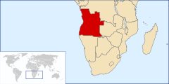
Angola is located on the western Atlantic Coast of Southern Africa between Namibia and the Republic of the Congo. It also is bordered by the Democratic Republic of the Congo and Zambia to the east. The country consists of a sparsely watered and somewhat sterile coastal plain extending inland for a distance varying from 50 to 160 km (31 to 99 mi). Slightly inland and parallel to the coast is a belt of hills and mountains and behind those a large plateau. The total land size is 1,246,700 km2 (481,400 sq mi). It has an Exclusive Economic Zone of 518,433 km2 (200,168 sq mi).