 | |
| Region | Caribbean |
|---|---|
| Coordinates | 17°03′N 61°48′W / 17.050°N 61.800°W |
| Area | Ranked 181st |
| • Total | 442.6 km2 (170.9 sq mi) |
| • Land | 95.33% |
| • Water | 4.67% |
| Coastline | 153 km (95 mi) |
| Borders | No land borders |
| Highest point | Boggy Peak 402 meters (1,319 ft) |
| Lowest point | Atlantic Ocean 0 metres (0 ft) |
| Longest river | None |
| Largest lake | Potsworks Reservoir 2.430 ha (6.00 acres) |
| Terrain | low-lying limestone and coral islands, with some higher volcanic areas |
| Natural resources | marine resources, cotton |
| Natural hazards | hurricanes and tropical storms (July to October); periodic droughts |
| Environmental issues | water management, deforestation |
| Exclusive economic zone | 110,089 km2 (42,506 sq mi) |

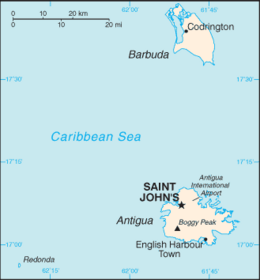
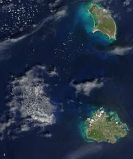
Antigua and Barbuda lie in the eastern arc of the Leeward Islands of the Lesser Antilles, separating the Atlantic Ocean from the Caribbean Sea.[1] Antigua is 650 km (400 mi) southeast of Puerto Rico; Barbuda lies 48 km (30 mi) due north of Antigua, and the uninhabited island of Redonda is 56 km (35 mi) southwest of Antigua.[1]
The largest island of Antigua, is 21 km (about a dozen miles) across and 281 km2 (about a hundred square miles) in area.[1] Barbuda covers 161 km2 (62 sq mi) while Redonda encompasses 2.6 km2 (1.0 sq mi).[1] The capital of Antigua and Barbuda is St. John's, located at St. John's Harbour on the northwest coast of Antigua.[1] The principal city of Barbuda is Codrington, located on Codrington Lagoon.[1]
In Antigua and Barbuda forest cover is around 18% of the total land area, equivalent to 8,120 hectares (ha) of forest in 2020, down from 10,110 hectares (ha) in 1990.[2][3]
- ^ a b c d e f Sturges-Vera, Karen (1987). "Antigua and Barbuda: Geography". In Meditz, Sandra W.; Hanratty, Dennis M. (eds.). Islands of the Commonwealth Caribbean: a regional study. Washington, D.C.: Federal Research Division, Library of Congress. pp. 435–437. OCLC 49361510.
 This article incorporates text from this source, which is in the public domain.
{{cite encyclopedia}}: CS1 maint: postscript (link) - ^ Terms and Definitions FRA 2025 Forest Resources Assessment, Working Paper 194. Food and Agriculture Organization of the United Nations. 2023.
- ^ "Global Forest Resources Assessment 2020, Antigua and Barbuda". Food Agriculture Organization of the United Nations.