This article needs additional citations for verification. (February 2013) |
 | |
| Continent | Europe |
|---|---|
| Region | Southeastern Europe |
| Coordinates | 44°N 18°E / 44°N 18°E |
| Area | |
| • Total | 51,209 km2 (19,772 sq mi) |
| • Land | 99.8% |
| • Water | 0.2% |
| Coastline | 20 km (12 mi) |
| Borders | Total land borders: 1,538 km |
| Highest point | Maglić 2,386 m |
| Lowest point | Adriatic Sea 0 m |
| Longest river | Drina |
| Largest lake | Hutovo Blato |

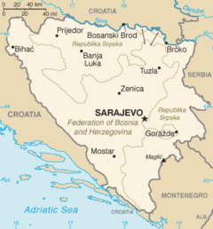
Bosnia and Herzegovina is located in Southeastern Europe. Situated in the western Balkans, it has a 932 km (579 mi) border with Croatia to the north and southwest, a 357 km (222 mi) border with Serbia to the east, and a 249 km (155 mi) border with Montenegro to the southeast.[1] It borders the Adriatic Sea along its 20 km (12 mi) coastline.
The most striking features of the local terrain are valleys and mountains which measure up to 2,386 m (7,828 ft) in height. The country is mostly mountainous, encompassing the central Dinaric Alps. The northeastern parts reach into the Pannonian basin, while in the south it borders the Adriatic Sea.
The country's natural resources include coal, iron ore, bauxite, manganese, nickel, clay, gypsum, salt, sand, timber and hydropower.[2]
- ^ "Op?i i geografski podaci o BiH". Archived from the original on 2016-03-06. Retrieved 2016-04-07.
- ^ "References :: Definitions and Notes — The World Factbook - Central Intelligence Agency". www.cia.gov. Retrieved 2019-11-02.[dead link]