 | |
| Continent | North America |
|---|---|
| Region | Central America |
| Coordinates | 15°00′N 86°30′W / 15.000°N 86.500°W |
| Area | Ranked 101st |
| • Total | 112,777 km2 (43,543 sq mi) |
| • Land | 99.82% |
| • Water | 0.18% |
| Coastline | 832 km (517 mi) |
| Borders | 1575 km (975 mi) |
| Highest point | Cerro Las Minas 2,870 metres (9,420 ft) |
| Lowest point | Caribbean Sea 0 metres (0 ft) |
| Longest river | Ulúa 400 km (250 mi) |
| Largest lake | Lake Yojoa 79 km2 (31 sq mi) |
| Exclusive economic zone | 249,542 km2 (96,349 sq mi) |

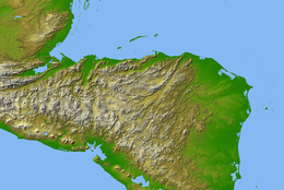
Honduras is a country in Central America. Honduras borders the Caribbean Sea and the North Pacific Ocean. Guatemala lies to the west, Nicaragua south east and El Salvador to the south west. Honduras is the second largest Central American republic, with a total area of 112,777 square kilometres (43,543 sq mi).
Honduras has a 700-kilometer (430-mile) Caribbean coastline extending from the mouth of the Río Motagua in the west to the mouth of the Río Coco in the east, at Cape Gracias a Dios.[1] The 922 km (573 mi) southeastern side of the triangle is a land border with Nicaragua.[1] It follows the Río Coco near the Caribbean Sea and then extends southwestward through mountainous terrain to the Gulf of Fonseca on the Pacific Ocean.[1] The southern apex of the triangle is a 153 km (95 mi) coastline on the Gulf Fonseca, which opens onto the Pacific Ocean.[1] In the west there are two land borders: with El Salvador as 342 km long (213 mi) and with Guatemala as 256 km long (159 mi).[1]
- ^ a b c d e
 This article incorporates text from this source, which is in the public domain: Echeverri-Gent, Elisavinda (1995). Merrill, Tim (ed.). Honduras: a country study (3rd ed.). Washington, D.C.: Federal Research Division, Library of Congress. pp. 66–74. ISBN 0-8444-0836-0. OCLC 31434665.