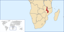

Malawi is a landlocked country in southeast Africa. It is wholly within the tropics; from about 9°30S at its northernmost point to about 17°S at the southernmost tip. The country occupies a thin strip of land between Zambia and Mozambique, extending southwards into Mozambique along the valley of the Shire River. In the north and north east it also shares a border with Tanzania. Malawi is connected by rail to the Mozambican ports of Nacala and Beira. It lies between latitudes 9° and 18°S, and longitudes 32° and 36°E.
The Great Rift Valley runs through the country from north to south. Lake Malawi lies within the rift valley, making up over three-quarters of Malawi's eastern boundary.[1] The Shire River flows down the rift valley from the south end of the lake to join the Zambezi River farther south in Mozambique.
Plateaus and mountains lie to the east and west of the Rift Valley. The Nyika Plateau lies west of Lake Malawi in the north of the country. The Shire Highlands lie in southern Malawi, east of the rift valley and Shire River and south of Lake Malawi. The Zomba and Mulanje mountain peaks rise from the highlands to respective heights of 2,100 and 3,000 metres (7,000 and 10,000 feet).[1]
Malawi has two sites listed on the UNESCO World Heritage List. Lake Malawi National Park was first listed in 1984 and the Chongoni Rock Art Area was listed in 2006.[2] Malawi's climate is hot in the low-lying areas in the south of the country and temperate in the northern highlands.