This article needs additional citations for verification. (April 2013) |
  | |
| Continent | Africa |
|---|---|
| Region | Western Africa |
| Coordinates | 16°00′N 08°00′E / 16.000°N 8.000°E |
| Area | Ranked 21st |
| • Total | 1,266,700 km2 (489,100 sq mi) |
| • Land | 99.98% |
| • Water | 0.02% |
| Coastline | 0 km (0 mi) |
| Borders | Land boundaries: Algeria 951 km Benin 277 km Burkina Faso 622 km Chad 1,196 km Libya 342 km Mali 838 km Nigeria 1,608 km[1] |
| Irrigated land | 736.6 km² (2005) |
| Total renewable water resources | 33.65 km3 (2011) |
| Highest point | Mont Idoukal-n-Taghès, 2,022 m |
| Lowest point | Niger River, 200 m |
| Climate | Hot desert; hot semi-arid in extreme southwest |
| Terrain | Mostly desert plains and sand dunes, hills in the north |
| Natural resources | Uranium, coal, iron ore, tin, phosphates, gold, molybdenum, gypsum, salt, petroleum |
| Natural hazards | Recurring droughts |
| Environmental issues | Overgrazing, soil erosion, deforestation, poaching |
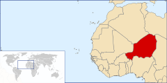
Niger is a landlocked nation in West Africa located along the border between the Sahara and Sub-Saharan regions. Its geographic coordinates are longitude 16°N and latitude 8°E
- ^ "The World Factbook". CIA.gov. Retrieved 20 April 2015.