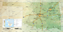

The Geography of Oklahoma encompasses terrain and ecosystems ranging from arid plains to subtropical forests and mountains. Oklahoma contains 10 distinct ecological regions, more per square mile than in any other state by a wide margin.[1] It is situated in the Great Plains and U.S. Interior Highlands region near the geographical center of the 48 contiguous states. Usually considered part of the South Central United States, Oklahoma is bounded on the east by Arkansas and Missouri, on the north by Kansas, on the northwest by Colorado, on the far west by New Mexico, and on the south and near-west by Texas.
The state has four primary mountain ranges: the Arbuckle Mountains, the Wichita Mountains, the Ozark Mountains and the Ouachita Mountains.[2] Part of the U.S. Interior Highlands region, the Ozarks and Ouachitas form one of the only major highland regions between the Rocky Mountains and the Appalachians.[3]
A portion of the Flint Hills stretches into north-central Oklahoma, and in the state's southeastern corner, Cavanal Hill is officially regarded as the world's tallest hill; at 1,999 feet (609 m), it fails the definition of a mountain by one foot.[4] More than 500 named creeks and rivers make up Oklahoma's waterways, and with 200 lakes created by dams, it holds the highest number of reservoirs in the nation.[4] Oklahoma covers an area of 69,898 square miles (181,030 km2), with 68,667 square miles (177,850 km2) of land and 1,231 square miles (3,190 km2) of water, making it the 20th-largest state in the United States.[5] Generally, it is divided into seven geographical regions: Green Country, or Northeast Oklahoma, Southeastern Oklahoma, Central Oklahoma, South Central Oklahoma, Southwest Oklahoma, Northwest Oklahoma, and the Oklahoma Panhandle.
- ^ "Oklahoma, All Terrain Vacation". TravelOK. TravelOK.com. 2006-01-12. Archived from the original on July 9, 2006. Retrieved 2006-07-15.
- ^ Cite error: The named reference
The Geography of Oklahomawas invoked but never defined (see the help page). - ^ "Managing Upland Forests of the Midsouth". USDA Forest Service. 2007-03-07. Archived from the original on 2008-06-22. Retrieved 2007-07-31.
- ^ a b "About Oklahoma". TravelOK.com. 2007. Archived from the original on 2006-07-07. Retrieved 2006-07-10.
- ^ "Land and Water Area of States, 2000". Information Please. 2000. Retrieved 2006-11-22.