 | |
| Continent | Pacific Ocean |
|---|---|
| Region | Oceania |
| Coordinates | 7°30′N 134°30′E / 7.500°N 134.500°E |
| Area | Ranked 179th |
| • Total | 459 km2 (177 sq mi) |
| • Land | 99% |
| • Water | 1% |
| Coastline | 1,519 km (944 mi) |
| Borders | None |
| Highest point | Mount Ngerchelchuus 242 metres (794 ft) |
| Lowest point | Pacific Ocean 0 m |
| Exclusive economic zone | 603,978 km2 (233,197 sq mi) |

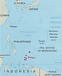
The Republic of Palau consists of eight principal islands and more than 250 smaller ones lying roughly 500 miles southeast of the Philippines, in Oceania. The islands of Palau constitute the westernmost part of the Caroline Islands chain. The country includes the World War II battleground of Peleliu and world-famous rock islands.[1] The total land area is 459 km2 (177 sq mi). It has the 42nd largest Exclusive Economic Zone of 603,978 km2 (233,197 sq mi).