 | |
| Region | South Central United States |
|---|---|
| Coordinates | 31°N 100°W / 31°N 100°W |
| Area | |
| • Total | 268,581 sq mi (695,620 km2) |
| Coastline | 367 mi (591 km) |
| Highest point | Guadalupe Peak, 8,749 feet (2,667 m) |
| Lowest point | Gulf of Mexico, sea level |
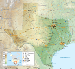
The geography of Texas is diverse and large. Occupying about 7% of the total water and land area of the U.S.,[1] it is the second largest state after Alaska, and is the southernmost part of the Great Plains, which end in the south against the folded Sierra Madre Oriental of Mexico. Texas is in the South Central United States of America, and is considered to form part of the U.S. South and also part of the U.S. Southwest.[2]
By residents, the state is generally divided into North Texas, East Texas, Central Texas, South Texas, West Texas and, sometimes, the Panhandle, but according to the Texas Almanac, Texas has four major physical regions: Gulf Coastal Plains, Interior Lowlands, Great Plains, and Basin and Range Province. This has been cited as the difference between human geography and physical geography, although the fact that Texas was granted the prerogative to divide into as many as five U.S. states may be a historical motive for Texans defining their state as containing exactly five regions.[3]
Some regions in Texas are more associated with the American Southeast (primarily East Texas, Central Texas, and North Texas). The Panhandle is part of the Great Plains and is considered by many to have more in common with parts of the Midwest than either the South or Southwest. Geographically and culturally, El Paso is closer to New Mexico or Arizona than it is to Austin or to East Texas. The size of Texas prohibits easy categorization of the entire state wholly in any recognized region of the United States, and even cultural diversity among regions of the state makes it difficult to treat Texas as a region in its own right.
- ^ "Texas' Natural Environment". Texas Almanac. Retrieved 2016-06-25.
- ^ Nova Lomax, John (March 3, 2015). "Is Texas Southern, Western, or Truly a Lone Star?". Texas Monthly. Retrieved September 6, 2016.
- ^ Cox, Mike (December 31, 2014) [November 4, 2004]. "New Geography: Remapping of the Lone Star State & Place Name Tweaking of Several Counties and County Seats". Texas Escapes.com. Texas Tales. Retrieved 2006-07-15.