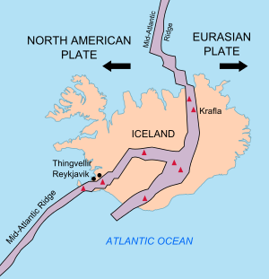

The geology of Iceland is unique and of particular interest to geologists. Iceland lies on the divergent boundary between the Eurasian Plate and the North American Plate. It also lies above a hotspot, the Iceland plume. The plume is believed to have caused the formation of Iceland itself, the island first appearing over the ocean surface about 16 to 18 million years ago.[1][2] The result is an island characterized by repeated volcanism and geothermal phenomena such as geysers.
The eruption of Laki in 1783 caused much devastation and loss of life, leading to a famine that killed about 25% of the island's population[3] and resulted in a drop in global temperatures, as sulfur dioxide was spewed into the Northern Hemisphere. This caused crop failures in Europe and may have caused droughts in India. The eruption has been estimated to have killed over six million people globally.[4]
Between 1963 and 1967, the new island of Surtsey was created off the southwest coast by a volcanic eruption.
- ^ Tobias Weisenberger (2013). "Introduction to the geology of Iceland".
- ^ "Catalogue of the Active Volcanoes of the World, Vol. 24" (PDF). Archived from the original (PDF) on 2013-11-13. Retrieved 2012-08-01.
- ^ Gunnar Karlsson (2000), Iceland's 1100 Years, p. 181
- ^ How The Earth Was Made: The Age of Earth (video), History.com