George F. L. Charles Airport Aéroport George F. L. Charles | |||||||||||
|---|---|---|---|---|---|---|---|---|---|---|---|
 | |||||||||||
| Summary | |||||||||||
| Airport type | Public | ||||||||||
| Owner | Government of Saint Lucia | ||||||||||
| Operator | Saint Lucia Air & Sea Ports Authority | ||||||||||
| Serves | Castries, Saint Lucia | ||||||||||
| Location | Vigie, Castries | ||||||||||
| Opened | 1941 | ||||||||||
| Hub for | Wiggins Airways[1] | ||||||||||
| Time zone | AST (UTC−04:00) | ||||||||||
| Elevation AMSL | 22 ft / 7 m | ||||||||||
| Coordinates | 14°01′13″N 060°59′35″W / 14.02028°N 60.99306°W | ||||||||||
| Website | http://www.stlucia-airport.com/ | ||||||||||
| Map | |||||||||||
| Runways | |||||||||||
| |||||||||||
| Helipads | |||||||||||
| |||||||||||
| Statistics (2016) | |||||||||||
| |||||||||||
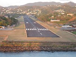
George F. L. Charles Airport (commonly known as Vigie Airport) (IATA: SLU, ICAO: TLPC) is the smaller of the two airports in Saint Lucia, the other being Hewanorra International Airport. It is located 2 km (1.2 mi) north of Castries, the capital city. George F. L. Charles Airport is managed by the Saint Lucia Air and Seaports Authority (SLASPA). Its runway runs parallel to a pristine beach, Vigie Beach, which is a popular tourist attraction.
- ^ "Route Map". 4 July 2017. Archived from the original on 27 February 2022. Retrieved 22 December 2020.
- ^ "Airport information for TLPC". World Aero Data. Archived from the original on 2016-03-03.
{{cite web}}: CS1 maint: unfit URL (link) Data current as of October 2006. Source: DAFIF.
