| Georgian Bay Islands National Park | |
|---|---|
| Parc national des Îles-de-la-Baie-Georgienne | |
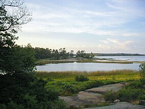
 Cedar Springs, Beausoleil Island | |
Location in Southern Ontario | |
| Location | Thirty Thousand Islands, Ontario, Canada |
| Nearest city | Midland, Ontario |
| Coordinates | 44°52′40″N 79°52′29″W / 44.87778°N 79.87472°W |
| Area | 13.5 km2 (5.2 sq mi) |
| Established | 1929 |
| Visitors | 27,482 (in 2022–23[1]) |
| Governing body | Parks Canada |
 | |
Georgian Bay Islands National Park (established 1929) consists of 63 small islands or parts of islands in Georgian Bay, near Port Severn, Ontario.[2] The total park area is approximately 13.5 km2 (5.2 sq mi). Prior to the creation of Fathom Five National Marine Park, Flowerpot Island was also a part of the park.[3]
The islands blend the exposed rocks and pines of the Canadian Shield with the hardwood forests found further south. The park can only be reached by boat and all of the islands are open to the public. Limited camping and docking facilities, trails and cabins are only available on the largest island, Beausoleil Island.[4]
It is part of the Georgian Bay Littoral Biosphere Reserve.
- ^ Canada, Parks. "Parks Canada attendance 2022_23 - Parks Canada attendance 2022_23 - Open Government Portal". open.canada.ca. Retrieved 2024-05-07.
- ^ "About - Georgian Bay Islands National Park". Parks Canada. Archived from the original on 5 April 2018.
- ^ "Saint Lawrence Lowlands". Parks Canada. 2009-04-15. Archived from the original on 2013-02-09. Retrieved 2011-10-20.
- ^ National Geographic Guide to the National Parks of Canada (Second ed.). Washington, D.C.: National Geographic Partners. 2017. pp. 132–137.

