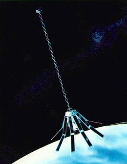
 Artist's interpretation of the Geosat satellite | |
| Mission type | Earth science |
|---|---|
| Operator | United States Navy |
| COSPAR ID | 1985-021A |
| SATCAT no. | 15595 |
| Mission duration | 5 Years |
| Spacecraft properties | |
| Dry mass | 635.0 kilograms (1,399.9 lb) |
| Start of mission | |
| Launch date | March 13, 1985, 02:00 UTC |
| Rocket | Atlas E/F OIS |
| Launch site | Vandenberg SLC-3W |
| End of mission | |
| Deactivated | January 1990 |
| Orbital parameters | |
| Reference system | Geocentric |
| Regime | LEO |
| Semi-major axis | 7,146.2 kilometres (4,440.4 mi) |
| Eccentricity | 0.00398 |
| Perigee altitude | 757 kilometres (470 mi) |
| Apogee altitude | 814 kilometres (506 mi) |
| Inclination | 108.0596 degrees |
| Period | 100.6 minutes |
| RAAN | 309.0682 degrees |
| Argument of perigee | 276.8275 degrees |
| Mean anomaly | 131.8715 degrees |
| Mean motion | 14.37442186 |
| Epoch | 9 December 2013 |
| Revolution no. | 50565 |

The GEOSAT (GEOdetic SATellite) was a U.S. Navy Earth observation satellite, launched on March 12, 1985 into an 800 km, 108° inclination orbit, with a nodal period of about 6040 seconds. The satellite carried a radar altimeter capable of measuring the distance from the satellite to sea surface with a relative precision of about 5 cm. The initial phase was an 18-month classified Geodetic Mission (GM) have a ground-track with a near-23-day repeat with closure to within 50 kilometers. The effect of atmospheric drag was such that by fall 1986 GEOSAT was in an almost exact 23-day repeat orbit.[1]
- ^ Born, G.H.; Mitchell, J.L.; Heyler, G.A. (1987). "Design of the GEOSAT Exact Repeat Mission" (PDF). APL-APL Tech. Dig. 8. Archived from the original (PDF) on 2016-08-16. Retrieved 2016-07-11.