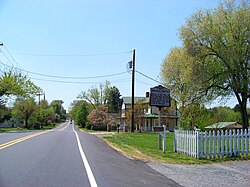
Germanton, North Carolina | |
|---|---|
 | |
| Coordinates: 36°15′46″N 80°13′51″W / 36.26278°N 80.23083°W | |
| Country | United States |
| State | North Carolina |
| Counties | Forsyth, Stokes |
| Founded | 1790[1] |
| Incorporated | 1874[2] (repealed 1895) |
| Named for | Germanic immigrants |
| Area | |
| • Total | 1.77 sq mi (4.58 km2) |
| • Land | 1.75 sq mi (4.54 km2) |
| • Water | 0.02 sq mi (0.04 km2) |
| Elevation | 696 ft (212 m) |
| Population (2020) | |
| • Total | 790 |
| • Density | 451.17/sq mi (174.18/km2) |
| Time zone | UTC-5 (Eastern (EST)) |
| • Summer (DST) | UTC-4 (EDT) |
| ZIP code | 27019 |
| FIPS code | 37-25880 |
| GNIS feature ID | 1020419[4] |
Germanton is an unincorporated community and census-designated place (CDP) in Forsyth and Stokes counties in the U.S. state of North Carolina, primarily in Stokes County. As of the 2020 census, the community had a population of 790. [5]
It is located 13 miles (21 km) south of the Stokes County seat of Danbury, on North Carolina State Highways 8 and 65 at an altitude of 662 feet (202 m). Downtown Winston-Salem is 13 miles (21 km) to the south. Germanton was the county seat of Stokes County prior to Forsyth County being created from southern Stokes. Before the creation of Forsyth County, Germanton was centrally located within the Stokes County limits.
- ^ "North Carolina Gazetteer". Retrieved November 24, 2023.
- ^ Carolina, North (1874). Laws and Resolutions of the State of North Carolina. Retrieved November 24, 2023.
- ^ "ArcGIS REST Services Directory". United States Census Bureau. Retrieved September 20, 2022.
- ^ a b U.S. Geological Survey Geographic Names Information System: Germanton, North Carolina
- ^ "Explore Census Data". data.census.gov. Retrieved September 5, 2023.

