| Gers | |
|---|---|
 Gers River in Auch | |
 | |
| Location | |
| Country | France |
| Physical characteristics | |
| Source | |
| • location | Plateau de Lannemezan |
| Mouth | |
• location | Garonne |
• coordinates | 44°8′40″N 0°38′52″E / 44.14444°N 0.64778°E |
| Length | 175.4 km (109.0 mi) |
| Basin size | 1,227 km2 (474 sq mi) |
| Discharge | |
| • average | 7.06 m3/s (249 cu ft/s) |
| Basin features | |
| Progression | Garonne→ Gironde estuary→ Atlantic Ocean Gers→ Garonne→ Gironde estuary→ Atlantic Ocean |
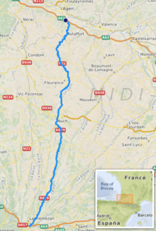
The Gers (French: [ʒɛʁ(s)] ) is a 175-kilometre (109 mi) long river in southern France, left tributary of the Garonne.[1]
Its source is in the foothills of the Pyrenees, near Lannemezan. It flows north through the départements Hautes-Pyrénées, Gers and Lot-et-Garonne. It flows into the Garonne in Layrac, near Agen. The city Auch lies along the river Gers. It gives its name to the Gers département.