| Gettysburg National Military Park Gettysburg National Park (1893) Gettysburg Park | |
|---|---|
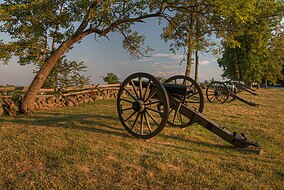
 Artillery on Seminary Ridge at Gettysburg National Military Park | |
| Nearest city | Gettysburg, Pennsylvania, U.S. |
| Coordinates | 39°48′31″N 77°14′12″W / 39.80861°N 77.23667°W |
| Area | 6,032 acres (24.41 km2) (as of 2020)[1] 2009: 3,965 acres 1963: 2,871 acres 1932: 2,530 acres 1916: ~2,302 acres[2] 1900: 1,221 acres 1888: 540 acres |
| Established | 1966: added to NRHP 1895: national park designation 1893: federal protection 1864: GBMA protection 1863: initial protection |
| Visitors | 1,031,554[citation needed] (in 2010) |
| Governing body | 1933: National Park Service 1896: War Department 1864: Gettysburg Battlefield Memorial Association |
| Website | Gettysburg National Military Park |
Gettysburg National Military Park | |
| Architect | Emmor Bradley Cope; William Saunders |
|---|---|
| NRHP reference No. | 66000642[3] |
| Added to NRHP | October 15, 1966 |
The Gettysburg National Military Park protects and interprets the landscape of the Battle of Gettysburg, fought over three days between July 1 and July 3, 1863, during the American Civil War. The park, in the Gettysburg, Pennsylvania area, is managed by the National Park Service.[4] Totaling 3,785 acres (1,532 ha) of area, it is mostly located in Cumberland Township, Adams County, Pennsylvania,[5] where it takes up almost 20% of the municipality's area.[6] Portions of the park extend into the Gettysburg borough limits,[7] including the Soldiers' National Cemetery,[8] and an exclave is in Mount Pleasant Township.[9]
The park's properties include most of the Gettysburg Battlefield, many of the battle's support areas during the battle, including reserve, supply, and hospital locations, and several non-battle areas associated with the battle's aftermath and commemoration, including the Gettysburg National Cemetery, where the Gettysburg Address was delivered by then President Abraham Lincoln on November 19, 1863.[10] Many of the park's 43,000 American Civil War artifacts are displayed in the Gettysburg Museum and Visitor Center.[11]
The park has more wooded land than in 1863, and the National Park Service has an ongoing program to restore portions of the battlefield to their historical non-wooded conditions, as well as to replant historic orchards and woodlots that are now missing. In addition, the NPS is restoring native plants to meadows and edges of roads, to encourage habitat as well as provide for historic landscape. There are also considerably more roads and facilities for the benefit of tourists visiting the battlefield park.
Attendance in 2018 was 950,000, a decline of 86% since 1970. The five major Civil War battlefield parks operated by the National Park Service (Gettysburg, Antietam, Shiloh, Chickamauga/Chattanooga and Vicksburg) had a combined 3.1 million visitors in 2018, down 70% from 10.2 million in 1970.[12]
The park was added to the National Register of Historic Places on October 15, 1966.[10][13]
- ^ "Listing of acreage – December 31, 2020" (XLSX). Land Resource Division, National Park Service. Retrieved 2021-08-15. (National Park Service Acreage Reports)
- ^ Cite error: The named reference
US1916was invoked but never defined (see the help page). - ^ "National Register Information System". National Register of Historic Places. National Park Service. November 2, 2013.
- ^ E011715 (June 29, 2009). "The New Visitor Experience at Gettysburg National Military Park, Facts at a Glance" (PDF). NPS.gov. Retrieved March 11, 2011.
{{cite web}}: CS1 maint: numeric names: authors list (link) - ^ "2020 CENSUS - CENSUS BLOCK MAP: Cumberland township, PA" (PDF). U.S. Census Bureau. Retrieved 2024-10-19.
Gettysburg Natl Mil Pk
- ^ "Cumberland Township History". Cumberland Township, Pennsylvania. Retrieved 2024-10-19.
- ^ "2020 CENSUS - CENSUS BLOCK MAP: Gettysburg borough, PA" (PDF). U.S. Census Bureau. Retrieved 2024-10-19.
Gettysburg Natl Mil Pk
- ^ "REGIONAL DEMOGRAPHICS" (PDF). Cumberland Township. p. A198 (PDF p.68/96). Retrieved 2024-10-19.
- ^ "2020 CENSUS - CENSUS BLOCK MAP: Mount Pleasant township, PA" (PDF). U.S. Census Bureau. Retrieved 2024-10-19.
Gettysburg Natl Mil Pk
- ^ a b Harrison, Kathleen Georg (November 4, 2003). "NRHP Registration Form: Gettysburg National Military Park/Soldiers' National Cemetery, update approved January 23, 2004". National Park Service – via National Archives Catalog for Pennsylvania. Downloading may be slow.
- ^ "Gettysburg Museum & Visitor Center". www.gettysburgfoundation.org. Retrieved July 7, 2021.
- ^ Cameron McWhirter, "Civil War Battlefields Lose Ground as Tourist Draws" Civil War Battlefields Lose Ground as Tourist Draws "The Wall Street Journal May 25, 2019
- ^ "Historic Resource Information: Gettysburg National Military Park". Pennsylvania Historical and Museum Commission – via CRGIS: Cultural Resources Geographic Information System for Pennsylvania.[permanent dead link]

