| Ghadir River | |
|---|---|
 | |
| Native name | نهر الغدير (Arabic) |
| Location | |
| Country | Lebanon |
| Physical characteristics | |
| Mouth | |
• location | Mediterranean Sea |
• coordinates | 33°49′10.992″N 35°29′45.996″E / 33.81972000°N 35.49611000°E |
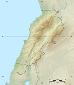
The Ghadir River (Arabic: نهر الغدير, romanized: Nahr Al-Ghadir), meaning rivulet, is one of the smallest rivers in Lebanon located in the southern Beirut region.[1] The river is formed by seasonal streams that form from rain in the Baabda district. The river passes through the areas of Choueifat, Kfarshima, Hay El Sellom and flows into the Mediterranean Sea south of Beirut, under the Beirut International Airport. It dries up totally during summer.
The Ghadir is the most polluted river in Lebanon. Although it has been polluted since the early 1990s, in 2017, the minister of public works Youssef Fenianos said that the water of the Ghadir was no longer normal water, it was sewage water.[2]
In its lower section, Al‐Ghadir River is connected to the Ghadir wastewater treatment plant as it acts as a sewerage and storm water conveyor. The river has turned into a sewerage because many households and industries located along it discharge untreated wastewater directly into it.[3] Example of such industries include tile factories and sand washing plants[4]
- ^ Bazzi, Mariam (22 September 2020). "Reclaiming Riparian Landscapes: The Case of Al-Ghadir River in Southern Beirut". AUB Students' Theses, Dissertations, and Projects: 91.
- ^ "نهر الغدير... عيب!". الأخبار (in Arabic). Retrieved 2021-11-23.
- ^ "Extension of Al‐Ghadir Wastewater Treatment Plant ‐ Lebanon" (PDF). European Investment Bank. p. 66. Retrieved 23 November 2021.
- ^ محطة تكرير نهر الغدير منجزة من عشرين سنة مع وقف التشغيل - جهاد زهري, retrieved 2021-11-23

