Ghorband
غوربند | |
|---|---|
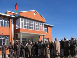
 Ghorband District courthouse in 2005 | |
 District highlighted within Parwan Province and Afghanistan | |
| Coordinates: 35°0′N 68°51′E / 35.000°N 68.850°E | |
| Country | Afghanistan |
| Province | Parwan |
| No. of Community Development Councils | 58 |
| No. of villages | 109 |
| Capital | Syagerd |
| Area | |
| • Total | 899 km2 (347 sq mi) |
| Population (2003) | |
| • Total | 74,123 |
| Time zone | UTC+4:30 (AFT) |
Ghorband (Persian: غوربند), also known as Syagird[1] after its main town, is a district of Parwan province, Afghanistan. It is located in the southern foothills of Hindu Kush and forms the western boundary of the ancient valley of Koh Daman.[2] The capital of Ghorband is the town of Syagird, which is about 2 hours of driving distance from Kabul.
Ghorband is the largest district of the province, covering an area of 899 square kilometres with a population of 74,123 as of 2003.[3]
The Ghorband River flows through the district. It contains 58 Community Development Councils and 109 villages.[3] Eventually, Ghorband valley was once much bigger then today reaching to the east Shibar, Doshi and Kahmard districts in Bamyan and Baghlan provinces.
- ^ "Afghan government says ceasefire still in place even as skirmieshes with Taliban resume". May 28, 2020 – via timesofindia.indiatimes.com.
- ^ Asiatic Society of Bengal (1836). Journal of the Asiatic Society of Bengal. Bishop's College Press. p. 6. Retrieved 3 January 2011.
- ^ a b "Summary of District Development Programme" (PDF). Islamic Republic of Afghanistan Ministry of Rural Rehabilitation and Development National Area Based Development Programme and United Nations Development Programme (UNDP). Archived from the original (PDF) on 7 July 2010. Retrieved 3 January 2011.