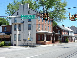
Gilbertsville | |
|---|---|
 Gilbertsville, E. Philadelphia Ave. | |
| Coordinates: 40°19′09″N 75°36′51″W / 40.31917°N 75.61417°W | |
| Country | United States |
| State | Pennsylvania |
| County | Montgomery |
| Township | Douglass
|
| Area | |
• Total | 3.35 sq mi (8.68 km2) |
| • Land | 3.35 sq mi (8.67 km2) |
| • Water | 0.00 sq mi (0.00 km2) |
| Elevation | 338 ft (103 m) |
| Population | |
• Total | 5,508 |
| • Density | 1,644.67/sq mi (634.97/km2) |
| Time zone | UTC-5 (EST) |
| • Summer (DST) | UTC-4 (EDT) |
| ZIP Code | 19525 |
| Area codes | 610 and 484 |
| FIPS code | 42-29096 |
Gilbertsville is a census-designated place (CDP) in Douglass Township in northwestern Montgomery County, Pennsylvania, United States. It is located at the junction of Routes 73 and 100. The population was 4,832 at the 2010 census, and the ZIP code is 19525. The name is also applied to an indeterminate adjacent section of New Hanover Township served by the Gilbertsville Post Office, located in Gilbertsville.[3] Boyertown Area School District provides public education to Gilbertsville. Gilbertsville is considered a exurb of Philadelphia, the nation's sixth-largest city, and is located to the city's northwest.
- ^ "ArcGIS REST Services Directory". United States Census Bureau. Retrieved October 12, 2022.
- ^ Cite error: The named reference
USCensusDecennial2020CenPopScriptOnlywas invoked but never defined (see the help page). - ^ "NEW HANOVER TOWNSHIP". www.newhanover-pa.org. Retrieved April 27, 2023.

