| Gilf Kebir | |
|---|---|
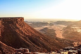
 View from the top of Gilf Kebir overlooking Wadi Sura | |
| Highest point | |
| Elevation | 1,014 to 1,016 m (3,327 to 3,333 ft) |
| Coordinates | 23°26′29″N 25°50′23″E / 23.44139°N 25.83972°E |
| Geography | |
| Country | Egypt |
Gilf Kebir (جلف كبير) (var. Gilf al-Kebir, Jilf al Kabir, Gilf Kebir Plateau) is a plateau in the New Valley Governorate of the remote southwest corner of Egypt, and southeast Libya. Its name translates as "the Great Barrier". This 7,770 km2 (3,000 sq mi) sandstone plateau, roughly the size of Puerto Rico, rises 300 m (980 ft) from the Libyan Desert floor. It is the true heart of the Gilf Kebir National Park.
The name Gilf Kebir was given to the plateau by Prince Kamal el Dine Hussein in 1925, as it had no local name.[1] It is known for its rugged beauty, remoteness, geological interest, and the dramatic cliff paintings-pictographs and rock carvings-petroglyphs which depict an earlier era of abundant animal life and human habitation.
- ^ F. J. R. R., "A Reconnaissance of the Gilf Kebir by the Late Sir Robert Clayton East Clayton" and P. A. Clayton, "The Western Side of the Gilf Kebir" Geographical Journal 81, 249-254 and 254-259, (1933)
