Gill, Massachusetts | |
|---|---|
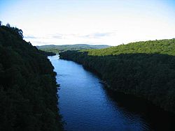
 The Connecticut River looking north in the early evening, from the French King Bridge at the Erving–Gill town line | |
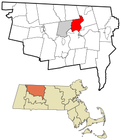
 Location in Franklin County in Massachusetts | |
| Coordinates: 42°38′25″N 72°30′00″W / 42.64028°N 72.50000°W | |
| Country | United States |
| State | Massachusetts |
| County | Franklin |
| Settled | 1776 |
| Incorporated | 1793 |
| Government | |
| • Type | Open town meeting |
| Area | |
| • Total | 14.8 sq mi (38.3 km2) |
| • Land | 13.7 sq mi (35.6 km2) |
| • Water | 1.0 sq mi (2.7 km2) |
| Elevation | 377 ft (115 m) |
| Population (2020) | |
| • Total | 1,551 |
| • Density | 100/sq mi (40/km2) |
| Time zone | UTC−5 (Eastern) |
| • Summer (DST) | UTC−4 (Eastern) |
| ZIP Code | 01354 |
| Area code | 413 |
| FIPS code | 25-25730 |
| GNIS feature ID | 0618164[1] |
| Website | www |
Gill is a town in Franklin County, Massachusetts, United States. The population was 1,551 at the 2020 census.[2] It is part of the Springfield, Massachusetts Metropolitan Statistical Area. The campus of Northfield Mount Hermon School is located in the Mount Hermon section of the town.
By sheer coincidence, "Gill" is the only full municipality of the 351 towns and cities currently administered in the Commonwealth of Massachusetts whose name has characters entirely in alphabetical order. No letter in "Gill" appears later than another letter that comes after it in the English alphabet. This quality is unique for any currently existing Massachusetts town name, as of early 2024.
