Girardot, Cundinamarca | |
|---|---|
Municipality and town | |
 | |
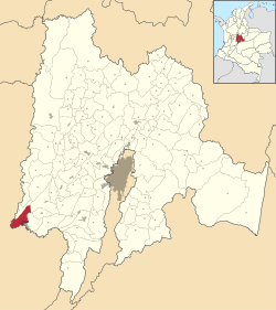
 Localization in Cundinamarca, in Colombia | |
| Coordinates: 4°18′18″N 74°48′06″W / 4.30500°N 74.80167°W | |
| Country | |
| Department | |
| Province | Upper Magdalena Province |
| Named for | ("Girardot") |
| Government | |
| • Type | Mayor–council |
| • Mayor | Jose Alejandro Arbeláez Cruz (L) |
| • Council | Girardot City Council |
| Area | |
| • Municipality and town | 130.32 km2 (50.32 sq mi) |
| • Urban | 22.6019 km2 (8.7266 sq mi) |
| • Rural | 107.7181 km2 (41.5902 sq mi) |
| • Metro | 355.42 km2 (137.23 sq mi) |
| Elevation | 326 m (1,070 ft) |
| Lowest elevation | 289 m (948 ft) |
| Population (2018 census)[5] | |
| • Municipality and town | 101,018 |
| • Rank | 6th Cundinamarca 59th Colombia |
| • Density | 780/km2 (2,000/sq mi) |
| • Urban | 95,427 |
| • Urban density | 4,200/km2 (11,000/sq mi) |
| • Rural | 5,591 |
| • Rural density | 52/km2 (130/sq mi) |
| • Metro | 142,288 |
| • Metro density | 400/km2 (1,000/sq mi) |
| Demonym | Girardoteño |
| Time zone | UTC-5 (COT) |
| • Summer (DST) | UTC-5 (COT) |
| Postal code | 252430-252439 |
| Area code | 57 + 1 |
| Website | Official website |
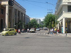
Girardot is a municipality and town of Colombia in the department of Cundinamarca. It is the second most important city of Cundinamarca according to its production. It is home to a number of recreational and vacational spots, mainly visited by people from Bogotá, as it is located at two hours drive from the city but enjoys a tropical climate (compared to the cold and rainy climate of Bogotá). The municipality had a population of 109,792 (2020 estimate),[6] and form a small metropolitan area together with the neighbouring municipalities of Flandes and Ricaurte.
- ^ a b Girardot (August 2011). "IUP" (PDF). Retrieved 23 July 2015.
{{cite journal}}: Cite journal requires|journal=(help) - ^ Girardot Council (9 June 2002). POT 029 2000 (PDF) (I ed.). Girardot: Girardot Council. Archived from the original (PDF) on 24 July 2015. Retrieved 23 July 2015.
- ^ Girardot Council (9 December 2011). OTP 24 2011. Girardot: Girardot Council. p. 39. Retrieved 24 July 2015.[permanent dead link]
- ^ Map of the Girardot metropolitan area from wikimedia
- ^ Citypopulation.de Population of Girardot municipality with localities
- ^ Citypopulation.de Population of Girardot municipality
Cite error: There are <ref group=lower-alpha> tags or {{efn}} templates on this page, but the references will not show without a {{reflist|group=lower-alpha}} template or {{notelist}} template (see the help page).


