Glastonbury Center, Connecticut | |
|---|---|
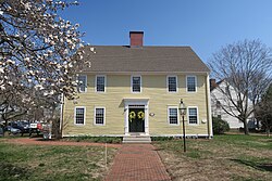
 Welles Chapman Tavern | |
| Coordinates: 41°42′44″N 72°36′31″W / 41.71222°N 72.60861°W | |
| Country | United States |
| State | Connecticut |
| County | Hartford |
| Town | Glastonbury |
| Area | |
• Total | 4.9 sq mi (12.7 km2) |
| • Land | 4.7 sq mi (12.3 km2) |
| • Water | 0.2 sq mi (0.4 km2) |
| Elevation | 50 ft (20 m) |
| Population (2010) | |
• Total | 7,387 |
| • Density | 1,500/sq mi (580/km2) |
| Time zone | UTC-5 (Eastern) |
| • Summer (DST) | UTC-4 (Eastern) |
| ZIP code | 06033 |
| Area code | 860 |
| FIPS code | 09-31270 |
| GNIS feature ID | 2377822 |
Glastonbury Center is a census-designated place (CDP) that constitutes the densely populated center of Glastonbury in Hartford County, Connecticut, United States. The population was 7,387 at the 2010 census,[1] out of a total town population of 34,427.
- ^ "Geographic Identifiers: 2010 Demographic Profile Data (G001): Glastonbury Center CDP, Connecticut". U.S. Census Bureau, American Factfinder. Archived from the original on February 12, 2020. Retrieved November 29, 2012.

