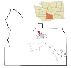
Gleed, Washington | |
|---|---|
 Location of Gleed, Washington | |
| Coordinates: 46°39′21″N 120°36′14″W / 46.65583°N 120.60389°W | |
| Country | United States |
| State | Washington |
| County | Yakima |
| Area | |
• Total | 5.4 sq mi (13.9 km2) |
| • Land | 5.4 sq mi (13.9 km2) |
| • Water | 0.0 sq mi (0.0 km2) |
| Elevation | 1,253 ft (382 m) |
| Population (2020) | |
• Total | 2,873 |
| • Density | 530/sq mi (210/km2) |
| Time zone | UTC-8 (Pacific (PST)) |
| • Summer (DST) | UTC-7 (PDT) |
| ZIP code | 98904 |
| Area code | 509 |
| FIPS code | 53-26945[1] |
| GNIS feature ID | 1512241[2] |
Gleed is a census-designated place (CDP) in Yakima County, Washington, United States. The population was 2,873 at the 2020 census.[3]
- ^ "U.S. Census website". United States Census Bureau. Retrieved January 31, 2008.
- ^ "US Board on Geographic Names". United States Geological Survey. October 25, 2007. Retrieved January 31, 2008.
- ^ "Census Bureau profile: Gleed, Washington". United States Census Bureau. May 2023. Retrieved May 9, 2024.