| Glen Innes New South Wales | |||||||||
|---|---|---|---|---|---|---|---|---|---|
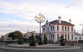
 Grey Street, Glen Innes | |||||||||
| Coordinates | 29°45′00″S 151°44′10″E / 29.75000°S 151.73611°E | ||||||||
| Population | 6,219 (2021 census)[1] | ||||||||
| Established | 1852 | ||||||||
| Postcode(s) | 2370 | ||||||||
| Elevation | 1,062 m (3,484 ft) | ||||||||
| Time zone | AEST (UTC+10) | ||||||||
| • Summer (DST) | AEDT (UTC+11) | ||||||||
| Location | |||||||||
| LGA(s) | Glen Innes Severn Shire Council | ||||||||
| County | Gough | ||||||||
| State electorate(s) | Northern Tablelands | ||||||||
| Federal division(s) | New England | ||||||||
| |||||||||
Glen Innes is a parish and town on the Northern Tablelands, in the New England region of New South Wales, Australia. It is the centre of the Glen Innes Severn Shire Council. The town is located at the intersection of the New England Highway and the Gwydir Highway. At the 2016 census, Glen Innes had a population of 6,155.[2]
- ^ "2021 Glen Innes, All persons QuickStats". Australian Bureau of Statistics. 2021. Retrieved 8 January 2024.
- ^ "Glen Innes (State Suburb)". Australian Bureau of Statistics. 6 July 2018. Retrieved 19 August 2018.
