| Glen Roy National Nature Reserve | |
|---|---|
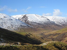
 The Parallel Roads of Glen Roy, highlighted by recent snowfall | |
| Location | Roybridge, Lochaber, Scotland |
| Coordinates | 56°58′N 4°46′W / 56.97°N 4.76°W |
| Area | 1,168.3 ha (4.511 sq mi)[2] |
| Established | 1970[1] |
| Governing body | NatureScot |
| Glen Roy National Nature Reserve | |

Glen Roy (Scottish Gaelic: Gleann Ruaidh, meaning "red glen"[3]) in the Lochaber area of the Highlands of Scotland is a glen noted for the geological phenomenon of three loch terraces known as the Parallel Roads of Glen Roy. The terraces formed along the shorelines of an ancient ice-dammed loch that existed during a brief period (some 900–1,100 years in duration) of climatic deterioration, during a much longer period of deglaciation, subsequent to the last main ice age (the Devensian). From a distance they resemble man-made roads running along the side of the glen, hence the name. Much of the glen is designated as a national nature reserve.[2]

Glen Roy runs north from Glen Spean which takes the main A86 trunk road and the railway of the West Highland Line, both running about a further 23 kilometres (14 mi) southwest via Spean Bridge to Fort William. The village of Roybridge and Roy Bridge railway station are sited where the River Roy joins the River Spean, and from there a narrow single-track road runs north up the glen for almost 16 kilometres (10 mi) to Brae Roy Lodge.

