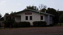
Glenbrook Beach
Kahawai | |
|---|---|
 Glenbrook Beach Community Hall | |
 | |
| Coordinates: 37°09′47″S 174°42′47″E / 37.163°S 174.713°E | |
| Country | New Zealand |
| Region | Auckland Region |
| Territorial authority | Auckland Council |
| Ward | Franklin ward |
| Board | Franklin Local Board |
| Electorates | |
| Area | |
| • Total | 1.17 km2 (0.45 sq mi) |
| Population (June 2024)[2] | |
| • Total | 590 |
| • Density | 500/km2 (1,300/sq mi) |
| Postcode | 2681 |
| Area code | 09 |
Glenbrook Beach is a rural community at the northern end of a peninsula formed between the Waiuku River and Taihiki River in Auckland, New Zealand. Waiuku is 14 km south by road.[3]
The area is also known as Kawahai, after a species of fish which has been a substantial food source for the local Ngāti Te Ata iwi.[4]
Glenbrook Beach was first subdivided in the mid 1920s.[5][6] Electric power supply was connected at the end of the decade.[7][8]
- ^ Cite error: The named reference
Areawas invoked but never defined (see the help page). - ^ "Aotearoa Data Explorer". Statistics New Zealand. Retrieved 26 October 2024.
- ^ Harriss, Gavin (March 2022). "NZ Topo Map" (Map). Glenbrook Beach, Auckland.
- ^ "Story of Kawahai". Auckland Council. Retrieved 18 August 2022.
- ^ "County Affairs—Glenbrook Beach". Franklin Times. 16 February 1925.
- ^ "Franklin County Works". New Zealand Herald. 23 January 1926.
- ^ "Local & General—Light for Glenbrook Beach". Franklin Times. 28 August 1929.
- ^ "Electric Power". Franklin Times. 23 October 1929.