Glendale | |
|---|---|
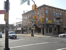
 Myrtle Avenue in Eastern Glendale | |
 Location within New York City | |
| Coordinates: 40°42′N 73°53′W / 40.7°N 73.88°W | |
| Country | |
| State | |
| City | New York City |
| County/Borough | Queens |
| Community District | Queens 5[1] |
| Founded | 1642 |
| Population | |
• Total | 32,496 |
| Race/Ethnicity | |
| • White | 61.4% |
| • Hispanic | 33.4 |
| • Asian | 3.1 |
| • Black | 1.2 |
| • Other/Multiracial | 0.9 |
| Time zone | UTC−5 (EST) |
| • Summer (DST) | UTC−4 (EDT) |
| ZIP Code | 11385 |
| Area codes | 718, 347, 929, and 917 |
Glendale is a neighborhood in the west-central portion of the New York City borough of Queens.[4] It is bounded by Forest Hills to the east, Ridgewood to the west, Woodhaven to the south, and Middle Village to the north.
Glendale was built on a swampy area previously called Fresh Pond. The neighborhood was later developed into an industrial area, though it is now a more residential neighborhood. Glendale's land area is long on its east-west axis and narrow on its north-south axis. The area is surrounded mainly by cemeteries, although the neighborhood also contains several large parks, including part of Forest Park.
Glendale is located in Queens Community District 5 and its ZIP Code is 11385.[1] It is patrolled by the New York City Police Department's 104th Precinct.[5] Politically, Glendale is represented by the New York City Council's 30th District.[6]
- ^ a b "NYC Planning | Community Profiles". communityprofiles.planning.nyc.gov. New York City Department of City Planning. Retrieved April 7, 2018.
- ^ Cite error: The named reference
PLP5was invoked but never defined (see the help page). - ^ Cite error: The named reference
PLP3Awas invoked but never defined (see the help page). - ^ Jackson, Kenneth T., ed. (1995). The Encyclopedia of New York City. New Haven: Yale University Press. p. 470. ISBN 0300055366.
- ^ Cite error: The named reference
NYPD 104th Precinctwas invoked but never defined (see the help page). - ^ Current City Council Districts for Queens County Archived December 22, 2016, at the Wayback Machine, New York City. Accessed May 5, 2017.